Brazilian-German Partnership to Improve Water Monitoring through Geospatial Intelligence
Lactec and EOMAP are partnering up to carry out projects in Brazil to improve mapping and monitoring of aquatic environments using geospatial intelligence.
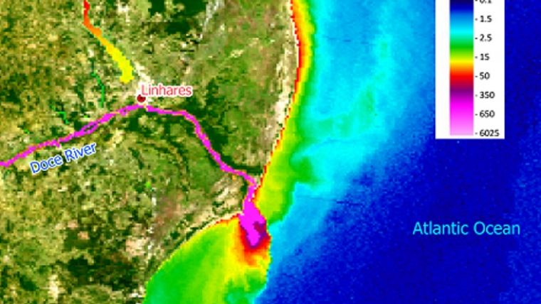
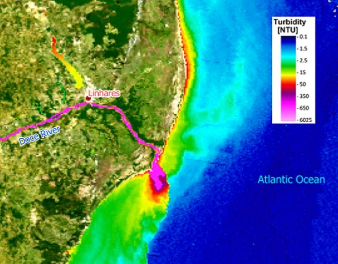
Lactec is Brazil's leading company in innovation and technological research, while EOMAP is a German company specialized aquatic remote sensing solutions. “Digital environmental monitoring is the way forward. We believe that the smart exploitation of big data collected from satellite imagery every single day is an impactful part of it. Lactec and EOMAP could prove this for the 2015 Mariana tailing dam disasters and, thanks to our partnership, will roll this out to many more applications and monitoring concepts within Brazil,” stated the two companies jointly. Thanks to their combined expertise, it was possible to get a full picture of the environmental impact caused by the 2015 Mariana tailing dam disaster in Minas Gerais, Brazil, on the Doce River basin and the adjacent coastal region. The experts applied satellite data analytics, modelling and in situ data and identified how the tailing mud spread through the river until it reached the ocean, compromising the water quality and the local biota.
This work will continue now with the evaluation regarding the consequences of the flooding registered in the region at the start of this year. With the flooding, the tailings that were deposited at the riverbed, along with the sediments in the Doce River and tributaries, possibly aggravated the environmental conditions of those ecosystems in terms of water quality.
Dense spatial data collection
Gheysa do Rocio Morais Pires, an environmental researcher at Lactec, explained that the remote sensing technology – associated with algorithms applied in EOMAP’s specific software – enables the collection of dense spatial data of the aquatic environment, such as temperature, turbidity, suspended solids and chlorophyll concentration. Among others, these are important parameters to determine water quality and were essential for the Mariana dam disaster and other environmental impact studies.
According to Henrique Reisdorfer Leite, a representative of EOMAP in Brazil who works closely with the Lactec team, the use of geospatial intelligence for environmental monitoring presents several advantages, such as spatial coverage, which is limited in field monitoring campaigns due to access difficulties and costs, and the possibility to evaluate the environmental conditions through time-series available on spatial agencies’ databases.
Validation of digital monitoring data
“Remote Sensing was essential in our work at the Doce River basin, because the satellite images allowed us to ‘go back in time’ and see the conditions in the rivers before and after the tailing dam disaster,” added Gheysa, noting that the digital monitoring data was validated by the analysis of samples collected in the field.
The same geospatial intelligence technologies and methodologies can meet the demands of companies in the electricity and sanitation sector, such as for the environmental monitoring of water reservoirs for example.
“The beauty of the new capabilities which we can jointly offer is that water quality parameters can be measured remotely, using big data from satellites. This enables us to provide frequent spatial mapping for all Brazilian waters. This brings a completely new dimension to the sampling and monitoring of how it is typically done and we believe that we can positively impact inland water monitoring concepts, and provide regional and national authorities as well as reservoir stakeholders with an excellent information source to base their decisions and reporting on,” continued Henrique.
Integrating remote sensing and hydrodynamic modelling
To name just another example, Lactec and EOMAP also combined their expertise in a research and development (R&D) project, carried out for China Three Gorges - CTG Brasil, in which an automated method was developed for monitoring the occurrence of aquatic macrophytes. It integrated remote sensing technologies and hydrodynamic modelling.
“We have worked with Lactec for many years and have appreciated their expertise and passion to introduce innovations in monitoring and managing reservoirs and in-land waters. Thus, it feels very natural that we combine our strengths to offer joint solutions for providing satellite-derived solutions to map and monitor aquatic environments in Brazil,” stated EOMAP’s COO, Knut Hartmann.

Value staying current with geomatics?
Stay on the map with our expertly curated newsletters.
We provide educational insights, industry updates, and inspiring stories to help you learn, grow, and reach your full potential in your field. Don't miss out - subscribe today and ensure you're always informed, educated, and inspired.
Choose your newsletter(s)


