Centenary of the Zuiderzee Act: a Masterpiece of Engineering
The Dutch Zuiderzee Act came into force exactly 100 years ago today, on 14 June 1918. The Zuiderzee Act signalled the beginning of the works that continue to protect the heart of The Netherlands from the dangers and vagaries of the Zuiderzee, an inlet of the North Sea, to this day. This amazing feat of engineering and spatial planning was a key milestone in The Netherlands’ world-leading reputation for reclaiming land from the sea. Wim van Wegen, content manager at ‘GIM International’, was born, raised and still lives in the Noordoostpolder, one of the various polders that were constructed. He has written an article about the uniqueness of this area of reclaimed land.
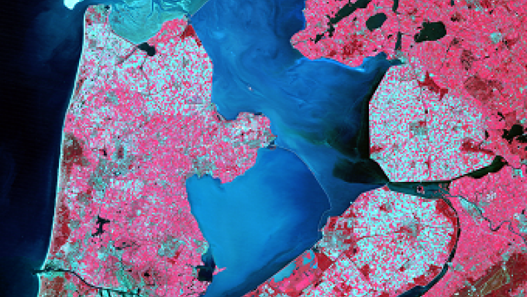
I was born at the bottom of the sea. Want to fact-check this? Just compare a pre-1940s map of the Netherlands to a more contemporary one. The old map shows an inlet of the North Sea, the Zuiderzee. The new one reveals large parts of the Zuiderzee having been turned into land, actually no longer part of the North Sea. In 1932, a 32km-long dam (the Afsluitdijk) was completed, separating the former Zuiderzee and the North Sea. This part of the sea was turned into a lake, the IJsselmeer (also known as Lake IJssel or Lake Yssel in English).
Why 'polder' is a Dutch word
The idea behind the construction of the Afsluitdijk was to defend areas against flooding, caused by the force of the open sea. The dam is part of the Zuiderzee Works, a man-made system of dams and dikes, land reclamation and water drainage works. But it was not only about protecting the Dutch against the threats of the sea; creating new agricultural land was another driving force behind this masterpiece. A third goal was to improve water management by creating a freshwater lake.
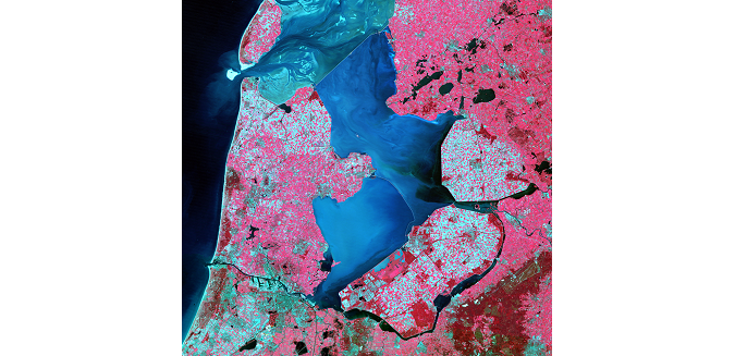
'Polder' is a Dutch word and this is no coincidence. There is an English saying: "God created the world but the Dutch created Holland". In 1930, the Wieringermeer was the first polder of the Zuiderzee Works that was drained, even before the construction of the Afsluitdijk was completed. The Noordoostpolder (North-East Polder) followed in 1942 and then in 1957 Eastern Flevoland and in 1968 Southern Flevoland. I was born in Emmeloord, the administrative centre of the Noordoostpolder, and grew up near a small village named Bant.
The story of the Noordoostpolder is also the story of my family. In 1941, while the pumping stations were still draining, my grandfather came to the Noordoostpolder as one of the early pioneers. The workers (called polder pioneers) were housed in wooden barracks. Cultivation began from the edges of the polder, and involved a lot of hard manual labour: digging ditches and trenches, fertilising, sowing and harvesting.

Value staying current with geomatics?
Stay on the map with our expertly curated newsletters.
We provide educational insights, industry updates, and inspiring stories to help you learn, grow, and reach your full potential in your field. Don't miss out - subscribe today and ensure you're always informed, educated, and inspired.
Choose your newsletter(s)


