CGG Launches MineScope for Insight Throughout the Mining Lifecycle
NPA Satellite Mapping, part of CGG’s Geoscience Division, has launched MineScope, a suite of satellite-derived services that enable mining companies and third-party consultants to make smarter geological, geotechnical and safety-related decisions throughout the mining lifecycle.
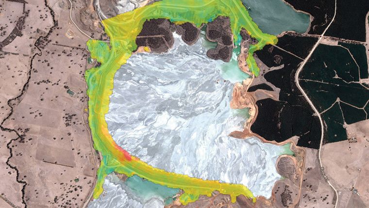
Mining can involve difficult decisions, operational challenges and risks. Recent tailings dam incidents in Australia and Brazil highlight the need for reliable geospatial intelligence that can strengthen awareness of site activities, geotechnical processes and evolving hazards.
MineScope is a comprehensive suite of remotely-captured, geospatial services that can improve exploration efficiency and situational awareness by reducing risk during the planning, auditing and monitoring of mine operations:
- For exploration activities, NPA Satellite Mapping’s mineral mapping expertise isolates potential mineral reserves prior to field-based reconnaissance and validation, saving time and money in the earliest stages of a mining project.
- For ‘pit-to-port’ operations, clients benefit from unique intelligence, including pit and stockpile volume calculations, tailings parameters, and ground deformation and slope stability (InSAR) measurements, together with the widest range of satellite imagery and topographic data available.
NPA Satellite Mapping’s status as an independent provider of satellite imagery guarantees unbiased advice on the optimal imagery for a project, and through MineScope, clients receive timely access to consistent complementary satellite-derived data products from a single, expert access-point.
Richard Burren, director of NPA Satellite Mapping, CGG, said “Since the launch of the first Landsat satellite in 1972, NPA Satellite Mapping has been at the forefront of providing intelligence derived from satellite imagery to the mining sector. In 2019, we continue to push the boundaries of what is achievable from today’s satellites and the expertise of our highly-experienced earth observation specialists, culminating in the development of MineScope. With the heightened need to improve the efficiency, safety and understanding of mining operations, MineScope directly supports our clients in better addressing some of the key challenges they face.”

Value staying current with geomatics?
Stay on the map with our expertly curated newsletters.
We provide educational insights, industry updates, and inspiring stories to help you learn, grow, and reach your full potential in your field. Don't miss out - subscribe today and ensure you're always informed, educated, and inspired.
Choose your newsletter(s)


