Consortium Starts High-resolution Layer Vegetated Land Cover Characteristics Project
The European Environment Agency (EEA) recently awarded a contract to implement the new High-Resolution Layer (HRL) Vegetated Land Cover Characteristics (VLCC), as part of the pan-European Copernicus Land Monitoring Service (CLMS). The contract has been awarded to a consortium under the lead of GAF, with the partners GeoVille and VITO.
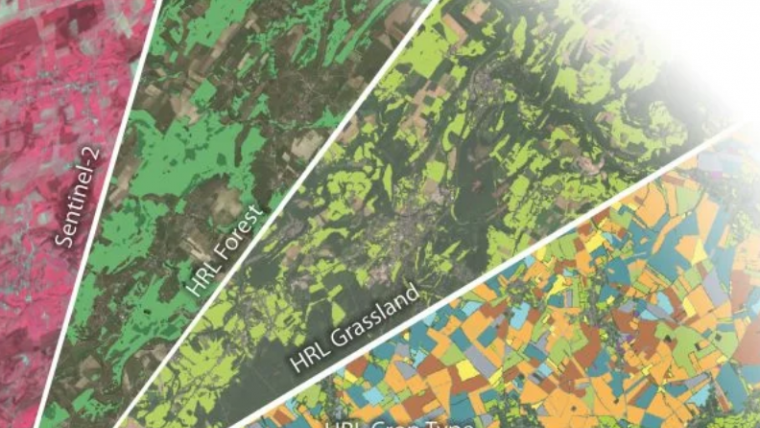
Its rich product portfolio will ensure both the continuation and evolution of successful precursor HRLs, such as Forest and Grassland, and the establishment of new HRL products focusing on crops and agricultural practises. The implementation of HRL VLCC will happen with funding by the European Union.
AI-based Technologies for Satellite Time Series Processing
With the new HRL Vegetated Land Cover Characteristics (VLCC), the European Environment Agency (EEA) will substantially extend and integrate the information content of its high-resolution vegetation monitoring products. The new VLCC will ensure continuity and further densification of the well-established HRL Forest and Grassland product time series. Furthermore, it will also shed additional light on a part of the European vegetation that has so far not been addressed in detail by Copernicus. André Stumpf, VLCC project manager at GAF, explains: “Drawing on the latest AI-based technologies for satellite time series processing in a highly integrated monitoring approach, VLCC will close the long-existing ‘crops gap’ in the European CLMS portfolio”.
In particular, the HRL VLCC will comprise pan-European mapping of several new agriculture-related CLMS products such as annual crop types, agricultural cropping patterns and grassland mowing until the year 2023, while ensuring consistency with the grassland and forest products. The VLCC will form part of the pan-European component of the Copernicus Land Monitoring Service (CLMS), making regular large-scale information products available to a broad user community from European public bodies, to EEA member and cooperating countries, regional environmental authorities, research and academia as well as the value-adding sector. It will provide support for various environmental policies and make a significant contribution to assessing Europe’s current environmental status and monitoring changes over time.
All related methodological and operational challenges will be addressed by a consortium with a long CLMS production track record, composed of GAF (Germany), GeoVille (Austria) and VITO (Belgium), supported by CLS (France) for independent validation and Evenflow (Belgium) for user involvement and dissemination. This team’s combined thematic and operational experience, together with application of the latest technologies, will ensure a fully compliant and sustainable project implementation that has a high level of consistency with the existing CLMS product portfolio.


Value staying current with geomatics?
Stay on the map with our expertly curated newsletters.
We provide educational insights, industry updates, and inspiring stories to help you learn, grow, and reach your full potential in your field. Don't miss out - subscribe today and ensure you're always informed, educated, and inspired.
Choose your newsletter(s)


