CryoSat Rolling for Re-calibration
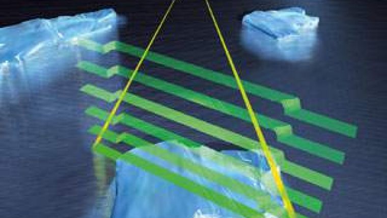
ESA's ice satellite is rolling left and right in orbit to help it continue its precise measurements of the vast ice sheets that blanket Greenland and Antarctica. This manoeuvre is to calibrate CryoSat's radar altimeter for measuring ice thickness, especially over the margins of ice sheets. The altimeter has two antennas mounted on a bench about a metre apart. When it is working in the ‘SARIn' mode, both antennas are used in parallel: one emits a signal and both receive the signals that bounce back.
Normally, this bench is parallel to Earth's surface. But at the edges of the ice sheets, the ice surface is not always flat and the slopes affect the return signals. Harsh conditions in space with huge temperature differences between Sun and shade can lead to the deterioration of CryoSat's instruments, which can also lead to measurement errors.
In order to quantify these errors, ESA ground controllers are working to recalibrate the altimeter. They are rolling the satellite to simulate the ice slopes and holding it in this position for several minutes. This must be done while CryoSat is over large, flat surfaces. For satellite altimeters, oceans are Earth's largest flat surfaces. It will also check whether errors are related to CryoSat's varying thermal conditions - like when exposed to the Sun or in the shade.
Since its launch eighteen months ago, CryoSat-2 has been collecting data to improve the understanding of the relationship between ice and climate. Just this year, the first map of Arctic sea-ice thickness was unveiled, and the satellite will continue to monitor the changing ice for years to come.
During several manoeuvres on Monday and Tuesday 17th and 18th October 2011, the satellite was rolling 0.4º to both sides while over the Indian and Pacific oceans, before returning to its original position.
The complex calibration is a joint effort between ESA's ESRIN centre for Earth observation in Italy and its ESOC operations centre in Germany.

Value staying current with geomatics?
Stay on the map with our expertly curated newsletters.
We provide educational insights, industry updates, and inspiring stories to help you learn, grow, and reach your full potential in your field. Don't miss out - subscribe today and ensure you're always informed, educated, and inspired.
Choose your newsletter(s)


