Digital Asset Management for Geospatial Data Launched
LizardTech and Extensis have announced the availability of Extensis Portfolio 2017, a digital asset management (DAM) solution optimised for geospatial data. Portfolio 2017 enables users to easily organise, access and share geospatial datasets - including compressed MrSID files - along with associated graphics and documents.
Divisions of Celartem, LizardTech and Extensis collaborated in adding geospatial data management capabilities to Portfolio, a DAM solution developed by Extensis. For more than 15 years, thousands of government agencies, businesses, universities, libraries, and museums have relied on Portfolio to centralise and manage digital assets. The DAM solution indexes and catalogues photographs, videos, maps, audio files, Adobe Creative Cloud applications and Microsoft Office documents.
Toby Martin, vice president of development and strategy at Extensis and LizardTech stated that in laying out the vision for Portfolio 2017, they saw a unique opportunity to marry the value of LizardTech and Extensis products and extend the value of DAM to new industries, particularly geospatial. For geospatial users, having a centralised repository for managing digital files will significantly reduce the time spent looking for datasets and essentially eliminate costly replacement of files that have been misplaced, he added.
Photogrammetry and Lidar
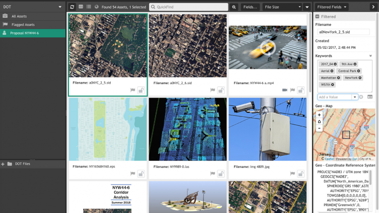
Portfolio 2017 gives users across the enterprise instant access to imagery (photogrammetry), Lidar and video data captured by satellite, aircraft and UAV platforms even if the files are stored on multiple networks, drives and computers. Geospatial files that have been compressed and saved in MrSID formats with the LizardTech GeoExpress solution can be loaded and viewed into Portfolio without any further data conversion. Dynamic panning and the ability to zoom in deeply to MrSID files in Portfolio expedite the process of assessing geospatial images, even in preview mode, and then pair with other documents such as proposals or presentations.
Now optimised for geospatial data, Portfolio extracts embedded metadata from compressed imagery and Lidar files saved in MrSID formats – in addition to other common geospatial formats such as GeoTIFF, JPEG 2000, NITF and LAS – for intelligent archiving. Geospatial data can be indexed and stored alongside associated non-geospatial photographs and documents for easy access.
Portfolio multiplies the value of geospatial assets by making them easier to share with many end users throughout the organsation as well as external partners, said Martin.
For data retrieval, users search by geographic coordinates or metadata tag, such as place name, acquisition date or sensor platform. Users can also search by defining an area of interest on a map interface. Portfolio instantly finds all geospatial tagged datasets meeting the criteria along with relevant non-geospatial documents. Results are displayed as preview thumbnails with the physical location of each digital file shown on a map.
To learn more about Portfolio, click here.

Value staying current with geomatics?
Stay on the map with our expertly curated newsletters.
We provide educational insights, industry updates, and inspiring stories to help you learn, grow, and reach your full potential in your field. Don't miss out - subscribe today and ensure you're always informed, educated, and inspired.
Choose your newsletter(s)


