Digital twin technology brings Pompeii to life
Researchers have been using GIS and 3D modelling techniques to create highly accurate maps of Pompeii. This has led to the development of a digital twin of the ancient Italian city, which was buried by ash from the eruption of Mount Vesuvius in 79 AD.
The Roman city of Pompeii, located near Naples, Italy, remained lost for almost 1,700 years until its rediscovery in the 18th century. Since then, archaeologists have been working to uncover and preserve the ruins of the city, providing insights into life during the Roman Empire.
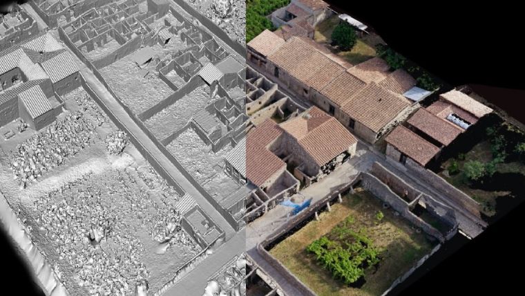
In recent years, several technologies have been introduced to the archaeological field, including GIS, 3D modelling and digital twins. These technologies have revolutionized the way archaeologists can document and analyse archaeological sites, and they are now being used to support work at Pompeii. According to an article in Geosmart Magazine, a team of Italian researchers has been using GIS and 3D modelling to create accurate maps of Pompeii. By creating detailed 3D models of the city and its surroundings, researchers can better understand the layout of the city and the relationships between its buildings, streets and other features. The use of GIS also allows researchers to incorporate other types of data, such as topographical information, into their analysis.
Digital technology unlocks Pompeii’s past
In conjunction with these efforts, another team of archaeologists has been working to create a digital twin of Pompeii, as reported by IoT World Today. The team used laser scanning technology to create a highly accurate 3D model of the city, from which they then created the digital twin. This twin can be used to simulate various scenarios, such as how the city might have looked during different time periods, and to better understand the impact of natural disasters on the city.
Pompeii is a compelling demonstration of how geospatial technologies such as satellite imagery, aerial photography, Lidar and digital twins can allow researchers to explore sites in new and innovative ways and provide valuable insights into ancient cities and their inhabitants. Experts believe that this is just the start of the groundbreaking impact that digital technology can have on archaeology and heritage studies, enabling people to not only access historical information but also to experience it in an immersive way. As a result, these advances have the potential to transform the field of archaeology and revolutionize the way we think about the past.

Value staying current with geomatics?
Stay on the map with our expertly curated newsletters.
We provide educational insights, industry updates, and inspiring stories to help you learn, grow, and reach your full potential in your field. Don't miss out - subscribe today and ensure you're always informed, educated, and inspired.
Choose your newsletter(s)


