Ecopia and Airbus to Provide Digital Maps on a Global Scale
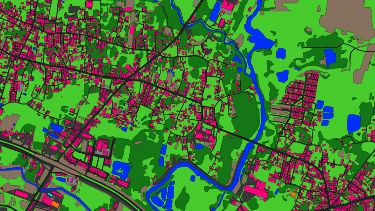
Ecopia AI has entered into a partnership with Airbus to produce next-generation digital maps on a global scale – including land use/land cover, roads and building footprint data. This digital mapping solution will provide commercial and governmental users with an accurate and up-to-date digital representation of their areas of interest, driving better decision-making across industries.
Under the agreement, Ecopia will have access to Airbus’ global premium 50cm high-resolution imagery database, applying their industry-leading artificial intelligence-based systems to extract vector maps on a city to continental scale – with the accuracy of a GIS professional. These vector maps known as Ecopia Vector Maps will be available within the Airbus OneAtlas Platform and upon request, and can be ordered for any location across the globe, empowering users with precise insights in just a few clicks.
Highly accurate maps for better decision-making
“We are excited to announce the growth of our partnership with Airbus,” said Jon Lipinski, co-founder, and president of Ecopia. “Having successfully executed several initiatives together over the past year, this collaboration will build on that track record – offering the next generation of digital maps at a global scale. These highly-accurate maps will help empower better decision-making at-scale, across a variety of industries including land administration, insurance, and other advanced applications.”
“Bringing together the powerful land classification and building footprint system from Ecopia, with the premium Airbus imagery from OneAtlas, enables users to have some of the most accurate and precise mapping features in the industry,” said Francois Lombard, head of the Intelligence Business at Airbus Defence and Space. “We very much look forward to seeing the partnership advance even further as Pléiades Neo 30cm data becomes available in the coming months.”

Value staying current with geomatics?
Stay on the map with our expertly curated newsletters.
We provide educational insights, industry updates, and inspiring stories to help you learn, grow, and reach your full potential in your field. Don't miss out - subscribe today and ensure you're always informed, educated, and inspired.
Choose your newsletter(s)


