Emesent Unveils Survey-grade Autonomous Lidar Mapping Solution
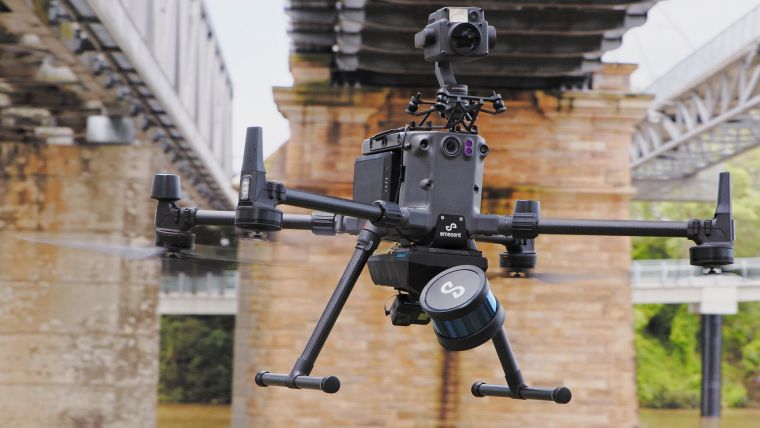
Emesent has launched Hovermap ST, the latest version of the Hovermap autonomy and mapping payload. The tough, lightweight, IP65-rated Hovermap ST includes Emesent’s new automated ground control feature.
With this powerful combination, Emesent aims to set the standard for survey-grade autonomous Lidar mapping in challenging environments.
Since its 2019 launch, Hovermap has made significant impacts in mining and other verticals, earning a reputation for versatility, ease of use and mapping data quality. With thousands of hours of autonomous flight logged by customers around the world, it is the most proven Lidar mapping and autonomy solution for challenging GPS-denied environments.
Hovermap ST including the ground control feature builds on this reputation with significant improvements, allowing autonomous data capture in even harsher environments and for a wider range of use cases.
“We’re excited to be providing our customers with a new, robust and reliable autonomous mapping tool for challenging environments, including those that were previously not well suited to SLAM-based mapping,” said Emesent CEO and Co-founder Stefan Hrabar.
Mapping Complex Environments with SLAM-based Systems
Simultaneous localization and mapping (SLAM)-based systems have proved their value for rapid mapping of complex environments, but achieving survey-grade accuracy and repeatability has been a challenge in some environments. Surveyors were faced with a compromise between fast data capture and data accuracy, depending on the job requirements.
This is no longer the case with Hovermap ST and the automated ground control feature, as the feature enhances the SLAM solution to remove SLAM drift and produce survey-grade, georeferenced point clouds. “This is a huge step forward for mobile mapping, providing unrivalled SLAM accuracy and workflow efficiencies,” said Hrabar.
Automated Constellation Matching
Emesent ground control targets are placed in the environment and captured in a continuous scan with Hovermap ST. There is no need to stop or place Hovermap on the targets, ensuring the capture process remains as efficient as before. The targets are automatically detected by Emesent’s SLAM processing engine and used to both improve the SLAM result and automatically georeference the point cloud to the control points. The process includes automated constellation matching between detected targets and known survey coordinates, eliminating cumbersome manual work which can introduce errors.
Hovermap ST has been redesigned from the ground up with robustness and reliability in mind, without compromising mapping quality. It features a lightweight, IP65 weather-sealed design, a powerful embedded computer for autonomy and mapping, and an accessory expansion port to further enhance its capabilities. The rotating Lidar produces up to 600,000 points per second in dual return mode, covering a near-spherical field of view.
Beyond Line of Sight
Hovermap’s Tap-to-Fly autonomy feature enables guided exploration in previously inaccessible areas beyond line of sight and communication range. The omnidirectional Collision Avoidance and smart Return-To-Home functions ensure assets are kept safe and valuable equipment is not damaged or lost.
Equally capable above ground or underground and indoors or out, Hovermap ST’s unique plug-and-play design enables seamless switching between drone-mounted, walking, vehicle-mounted or backpack-mounted scanning, providing the versatility needed to capture data anywhere.
This powerful combination of precision engineering, world-leading SLAM algorithms and robust drone autonomy capabilities provides accurate Lidar mapping for monitoring construction, bridge scans, road surveys or creating digital twins.
Data capture experts worldwide have been using Hovermap to map challenging and dangerous environments, from entire municipalities for improved development planning to road tunnel inspections for identification of defects.


Value staying current with geomatics?
Stay on the map with our expertly curated newsletters.
We provide educational insights, industry updates, and inspiring stories to help you learn, grow, and reach your full potential in your field. Don't miss out - subscribe today and ensure you're always informed, educated, and inspired.
Choose your newsletter(s)


