Enabling Vehicle-to-infrastructure Solutions with Smart Lidar and AI
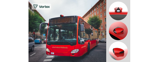
Cepton Technologies and Vortex have combined their skills to turn buses in the UK into real-time road inspection tools. The solution is based on a Lidar-based vehicle-to-infrastructure (V2I) system for urban asset management, called CURBS. Cepton Technologies is a provider of smart Lidar solutions, while Vortex is a UK-based Internet of Things (IoT) solutions company.
AI and machine learning meets Lidar technology
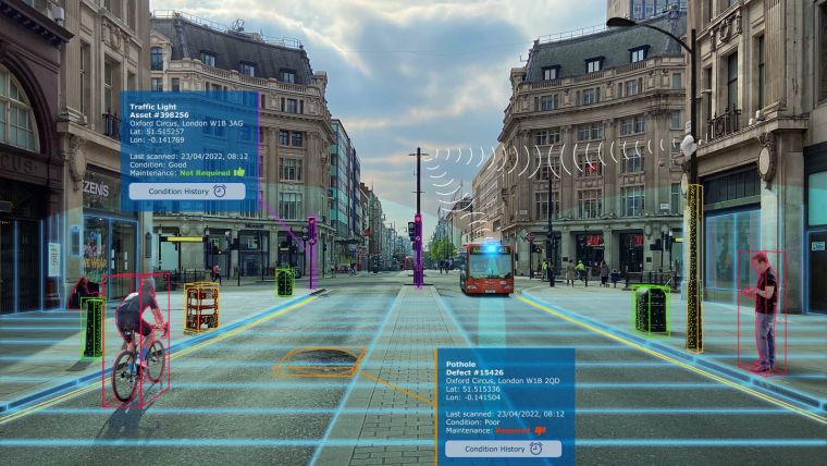
Vortex’s Lidar-powered Continuous Urban Scanner System (CURBS) uses artificial intelligence (AI) and machine learning alongside Cepton’s Vista-P60 high-resolution Lidar sensors to create a detailed map of the urban environment. This is done by retrofitting the CURBS product to vehicles to create a real-time 3D scanning and dynamic monitoring system. Mounted on public transportation, such as bus fleets, refuse collection trucks or mobile enforcement vehicles, the Lidar-embedded CURBS solution is able to pinpoint areas that may need repair, allowing for the early identification of issues and the mobilization of maintenance teams.
CURBS streams the processed information over 5G networks. Crucially, this information helps to not only provide real-time insights to services such as road maintenance, but also to drive intelligent decisions with the goal of optimizing traffic management, such as enabling preventive measures in accident-prone areas and improving the efficiency of traffic. These anticipated improvements are intended to ultimately help drive down carbon emissions while also making cities safer and smarter.
5G supports innovative 3D maps
The solution is currently being piloted in the West Midlands in a government-sponsored 5G programme called ‘WM5G’. Vortex has partnered with National Express and BT for the project. “The mission of the WM5G Transport team is to support 5G innovation within the region to make transport networks safer, more sustainable and more intuitive to users,” said David Conner, project manager at WM5G Transport. “By enabling powerful connectivity to transfer large amounts of Lidar and camera data, 5G supports the generation of 3D maps capable of providing the insights required to enhance road safety and guide the development of smart cities.”
Vortex also has additional deployments scheduled with traffic enforcement and smart city management company, Marston Holdings. “With vehicles becoming increasingly smarter, city infrastructure also demands next-generation innovations to deliver matching intelligence. Smart city solutions like CURBS are set to become commonplace across our towns and cities,” said Adrian Sutton, co-founder and CEO of Vortex. “Public authorities need efficient, scalable ways to manage urban environments, and this becomes even more important as the focus on issues such as decarbonization, sustainability and climate change grows. At the heart of this is digital transformation and the potential that connected technologies and data analytics present for asset management in real time. Enhanced use of big data will drive rapid urban planning and dynamic decision-making. Here, perception is key, and nothing can produce accurate 3D data in real-life urban environments quite like Lidar.”
Mounted on public transportation, CURBS utilizes Lidar to provide detailed 3D point cloud visualizations of each vehicle’s surroundings as it travels. This enables asset and infrastructure management by identifying certain situations such as potholes, surface damage and roadside defects in real time. 5G wireless technology is used to transmit the data to road management teams. (Image courtesy of Vortex)
Lidar sensors for challenging circumstances
Cepton’s Lidar solutions combine high resolution and long range while enabling sensor robustness and reliability, and CURBS leverages a number of benefits through its use of Cepton’s Vista-P60 sensors. Firstly, the Lidar sensors perform with accuracy and resilience in a variety of weather and lighting conditions. In contrast, cameras need sufficient light to be effective and can be blinded by strong light. Because cameras provide only two-dimensional imaging typically with no accurate size and location data, they need additional computing resource to process the image to extract useful information, which might take up more bandwidth and lead to lag.
Secondly, Lidar data is completely anonymized, protecting the privacy of citizens and eliminating the need for additional data management and security protocols. Lidar collects no biometric data, making individual features unidentifiable from Lidar point cloud visualizations.
Lastly, the Vista-P60 Lidars, powered by Cepton’s Micro Motion Technology (MMT), are non-rotational, mirrorless and frictionless. This makes it possible for the sensor to deliver high performance while offering a low-power and compact solution to help drive down integration and maintenance costs. The scalability of the Vista-P60 Lidars make them ideal for V2I smart city applications like CURBS.

Value staying current with geomatics?
Stay on the map with our expertly curated newsletters.
We provide educational insights, industry updates, and inspiring stories to help you learn, grow, and reach your full potential in your field. Don't miss out - subscribe today and ensure you're always informed, educated, and inspired.
Choose your newsletter(s)


