Engineering to ‘Bridge the Gap’ on Laser Scanning
It is no secret that where large-scale major investment is concerned in the current economic climate, infrastructure is a serious front-runner. As one component of a multi-pronged assault on rectifying the UK’s extensive debt crisis, the British government has pledged billions of pounds to the preservation and vast improvement of the country’s arterial infrastructure systems in the hope of kick-starting the country’s long-term economic growth.
With high-profile projects such as HS2 and Crossrail at the vanguard of the GBP36billion major infrastructure investment plan, the subject of national infrastructure was one of 2014’s hot topics.
Opti-cal, a supplier of land survey and precision measurement technologies based in the UK, caught up with Ted Harland of Tri-tech Site Engineering and Land Surveys in a bid to get the inside scoop on one of this year’s largest projects; the high profile GBP300million upgrade of the A1 between Barton and Leeming, that upon completion will see journey times in the area cut by as much as 20 percent.
Tri-tech themselves are a Yorkshire-based surveying and site engineering company, who since 2005 have gained a solid reputation in supporting and facilitating project success for both public and private sector clients.
Lowdown
The project is essentially a GBP300m upgrade of the existing A1 dual carriageway to a 3-lane motorway, explained Harland, MD of Tri-tech. Upon completion, the project will also provide a number of local access roads to serve the local community, and significantly improve safety in the area – which at present lacks the local access roads necessary to accommodate the area’s numerous agricultural vehicles.
Falling beneath the broad umbrella of major infrastructure projects for 2014/15, the A1 upgrade sets the tone for contemporary project processes in its use of 3D Laser Scanning technology, as well as the insight into futureproofing the venture’s work through BIM (Building Information Modelling) workflows. There has been a big push nationwide to start to deliver projects through BIM, said Harland. This, in combination with the recent development of scanners, PC software, and PC hardware, has meant that 3D laser Scanning has become a viable option for data collection for this kind of project. Tri-tech have used Opti-cal for a number of years now for the supply and service of all their equipment.
Focus3D
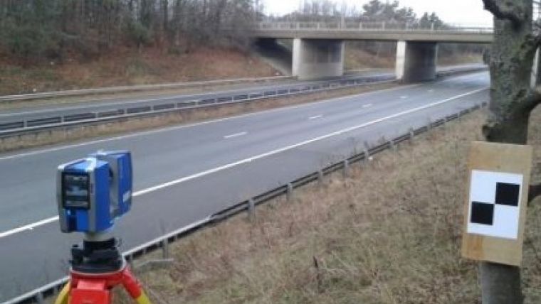
The company was asked by the Morgan-Sindall Carillion Joint Venture (MSCJV) project team to survey a number of existing bridges for the structural design team to process. Harland explained that some of the existing bridges are to be kept, as well as a number modified to suit a new 3-lane motorway. After having various discussions with the design team about their specific requirements, and whether they could handle such large amounts of scan data, Tri-tech chose the FARO Focus3D X330 model for the job largely because it has the ability to scan at afar.
Since its arrival on the market last year, the FARO Focus3D Laser Scanner from global manufacturer FARO has evolved in tandem with the changing requirements of the survey teams using it. In November last year, the original S120 model was replaced by the first of the X series units – the X330 – which boasted considerable range whilst maintaining the compact 5kg housing that has gained this particular brand of scanner industry-wide recognition. In the past Tri-tech has used the Focus3D S120 to scan a number of buildings for a client, Ted Harland said. The results were excellent, however on this project they knew they required the additional range of the X330 to confidently scan the structures from both sides of the carriageway and get good results. Because they only have access to the side of the motorway sometimes the distances needed to be scanned would have been right at the limit of the S120, which is why they went for X330. In terms of the hire itself, they have used Opti-cal for number of years now and so it was natural progression for them to supply the scanner and all accessories.
Data
Speaking about the data captured at the site, Peter Robinson of AECOM’s specialist design team said that the use of the X330 FARO scanner by Ted Harland of Tri-tech has provided the A1 Dishforth to Barton structures design team with invaluable information. The level of detail obtained from the surveys has allowed accurate modelling of existing structures. Thanks to the coordinated point cloud obtained from the surveys conducted, they discovered that the original surveys carried out at the site were in fact inaccurate, which could easily have led to costly issues on site.
Robinson highlighted the very issue that awards laser scanning its rightful place at the heart of much of the industry’s recent lean towards Level 2 maturity BIM workflows: that the data you get out of a model will only ever be as good as the data you put in. And where Tri-tech are concerned, no expense has been spared in ensuring total accuracy for MSCJV and the holistic success of their project.
There was quite a lot of prep work prior to the scanner arriving on site, Harland continued. Control had to be established at each structure using GPS and then tightened up using a total station; all stations were then digitally levelled to tie them into the site network. The beauty about scanning and scan data is that you capture everything in one visit – which at the end of the day saved the project both time and money.
Data procession
They managed to scan all the structures in 4 days with a total of over 40 scans taken, said Harland. The processing was then done the following week using the Faro Scene, and the data exported out of FARO Scene Software in a format ready to be imported into Autodesk Revit/Autocad. They know this data is of an exceptionally high quality, and can now be used to design and model all new additions or changes to the motorway bridges – it also provides a real snapshot of what is there now as a record forever, in true 3D.
With work commencing in March this year, the venture is by no means a small undertaking. The project is due to be completed in mid-2017, Harland added. He is confident that should there be any further survey work of bridges or structures, laser scanning will certainly be a first choice – not only by the designers but by the site team too.
This user story was written by FARO's British reseller.

Value staying current with geomatics?
Stay on the map with our expertly curated newsletters.
We provide educational insights, industry updates, and inspiring stories to help you learn, grow, and reach your full potential in your field. Don't miss out - subscribe today and ensure you're always informed, educated, and inspired.
Choose your newsletter(s)


