Exploring Aboriginal Caves with Mobile 3D Laser Mapping System
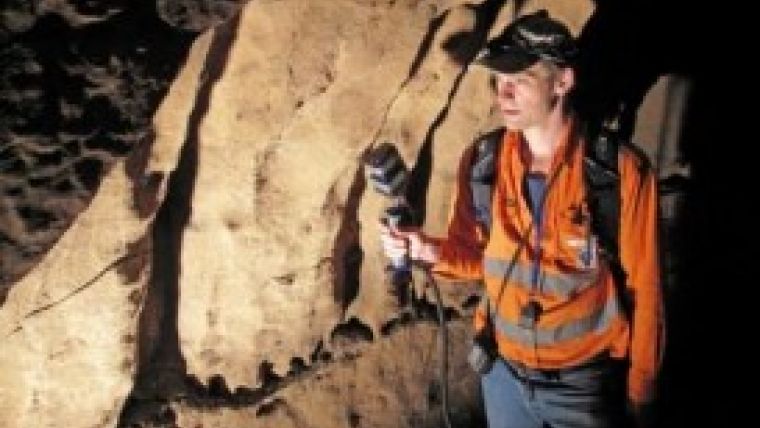
ZEB1, a truly mobile handheld rapid laser mapping system, has been used to explore Aboriginal cave markings in South Australia. Using the ZEB1 handheld mobile mapping system, researchers have been able to create a detailed 3D survey of the cave system. This 3D survey data, combined with high-resolution photographs and analysis of the flutings, can be analysed by archaeologists from the SA Museum.
The strange markings, called finger flutings, were thought to have been left in the Koonalda Cave between about 30,000 and 10,000 years ago. Created by hands being dragged along established grooves in the soft limestone walls, the markings are extremely fragile and crumble at the slightest touch.
Archaeologist Dr Keryn Walshe from the SA Museum said the ZEB1 is a fantastic research tool; the models can be used in the lab where the light and working conditions are good. In the cave, which is often in complete darkness, it is really hard to do the research. Dr Walshe commented she is keen to determine who made the markings; men, women or children. It is really tempting - it is really hard, actually - not to touch the soft surface because it is so inviting. It is this beautiful pure white colour, like snow, she added.
The ZEB1 system includes a lightweight laser scanner mounted on a simple spring mechanism. As the operator moves through an environment the scanner loosely oscillates about the spring producing a rotation that converts 2D laser measurements into 3D fields of view. Its ability to self-localise makes ZEB1 ideally suited for use indoors, underground and in other covered environments, such as dense forest and urban canyons, where traditional solutions that utilise GPS do not function well. The 3D survey of the caves, created using ZEB1, can be analysed in detail using CAD-type visualisation software. The data can also be used to create physical reconstructions of the caves using 3D printers.
The ZEB1 mobile mapping system was developed by CSIRO, Australia’s national science agency, and is licenced from GeoSLAM (a UK based start-up company). The competitively priced ZEB1, now exclusively available from 3D Laser Mapping, allows for fast data capture, without complex set up or the requirement for lengthy data processing and can be used by surveying novices, in areas without GPS coverage, capturing accurate 3D point clouds at speed.
A product video can be viewed here.

Value staying current with geomatics?
Stay on the map with our expertly curated newsletters.
We provide educational insights, industry updates, and inspiring stories to help you learn, grow, and reach your full potential in your field. Don't miss out - subscribe today and ensure you're always informed, educated, and inspired.
Choose your newsletter(s)


