GCPs for Satellite Image Georeferencing Surveyed Worldwide with GNSS PPP
GNSS positioning by precise point positioning (PPP) has developed over the last few years and is frequently used by the scientific community. Its real-time or post-processing applications are already used in several fields (e.g. in farming for tractor guidance or in aerial survey for calculating flight paths), but despite this its use remains relatively low with surveyors, mainly due to the initialisation time.
This method, however, can prove to be effective, particularly in regions where there are no or few permanent GNSS stations (CORS) to establish a geodetic survey traverse and fix ground control points (GCPs) for aerial or satellite images.
Post-Processing Observation
Articles in the specialist press as well as the tests carried out by TopoSat show that several hours of post processing observation is necessary to obtain accuracy to the nearest centimetre. However, it is possible to obtain accuracy to the nearest 5cm in only one hour and better than 15 to 20cm in under 30 minutes, which can be suitable for GCP observations when orthorectifying satellite images with 50cm pixels. Finally, this level of estimated accuracy is shown by processing software for the statistical criteria relating to solution convergence, although surveyors are more used to a minimum qualification achieved by independent double resolution. It is nevertheless possible to satisfy this demand by carrying out the calculation through 2 interfaces:
- Software or an online calculation site using epherimedes calculated by IGS,
- The Trimble RTX website which uses its own network of permanent stations to determine precise orbits and other parameters.
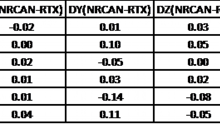
The comparison is made on the ECEF co-ordinates in ITRF2008 (measurement epoch). Each time the gap between the two fixes is within the uncertainty interval mentioned above, and depending on the time spent on observation.
The tables (see above) show an example of gaps obtained for 30 minutes of observation between the results from the website www.trimblertx.com and those from NRCAN (www.nrcan.gc.ca – Geomatics section) as well as the indicated uncertainty.
TopoSat has used this double determination in Africa on several occasions over the last 4 or 5 years, by adapting the observation period to the required precision:
- To establish geodetic survey traverses along road construction or electricity line works.
- To determine unconnected GNSS base stations when fixing the GCP of aerial images on a large surface area, which avoids creating a geodetic network and allows trips over tracks, which are often difficult, to be kept to a minimum.
Furthermore, recently (between 2013 and today), TopoSat has collected nearly 2400 GCPs located mainly around major international airports for 50cm resolution images and spread over 450 sites, 93 countries and 4 continents. These points are available for purchase. Their distribution can be seen on the map.
An interactive map is available on http://gcp.toposat.com. A kml file with all collected GCP’s and links to descriptive sheets can be downloaded on the same page.
About TopoSat
Created in 1990 by qualified Surveying Engineer Bertrand Boullard - a graduate of the prestigious French ESTP School - TopoSat provides services focusing on the use of GPS/GNSS positioning techniques. TopoSat operates throughout France and all over the world.
Figure 1, Comparison of results (in cm)
Figure 2, Uncertainty (in cm) shown by calculation websites

Value staying current with geomatics?
Stay on the map with our expertly curated newsletters.
We provide educational insights, industry updates, and inspiring stories to help you learn, grow, and reach your full potential in your field. Don't miss out - subscribe today and ensure you're always informed, educated, and inspired.
Choose your newsletter(s)


