Multi-dimensional Cadastre: 3D and 4D
3D Data for Environmentally and Energetically Relevant Topics
In recent years, Germany's national mapping and cadastre information systems have become increasingly focused on demands for multidimensional applications, e.g. environmental protection, planning, energy supply and disaster management. The basic request of coverage and actuality was previously defined for the third dimension. In 2009, the Surveying Authorities of the States of the Federal Republic of Germany (AdV) arrived at the following decision: “The collection, data modelling and quality management of buildings for geotopographical surveying and for the cadastre are main tasks of the official German cadastre. This also includes the third dimension.” The fourth dimension (time) is now an integral component of the new German cadastral information system.
Need for 3D Building Information
In Germany the government targets for climate and environmental protection are currently producing extensive changes in the energy sector, the so-called ‘energy turnaround’. This includes cessation of the use of nuclear energy by 2020, reduction of greenhouse gases and other objectives. As a result, planning processes especially have to take into account the use of photovoltaic technology, geothermal energy, wind energy and the energetic isolation of buildings. From a process perspective, data must be available to provide actual information of the environment and all energetically relevant topics in combination with up-to-date 3D building information. Very often this leads to a data-collection or at least to a data-processing task. Based on the required information, the analysis and evaluation will give a sustainable picture of the energy balance, including possible savings from the use of renewable energy and energetic isolation of buildings.
Urban planning
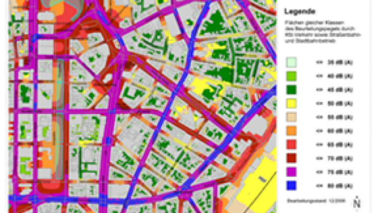
 3D geometry and semantics, particularly of buildings, are also useful in the field of noise protection in terms of simulating and mapping noise expansion. A European Directive obliges the member states of the European Union to determine and to document noise pollution in cities every five years, and to check the progress of noise reduction. The use of cadastral information for urban planning has always been essential, even in the 2D world, especially to consider the property distribution. Nowadays 3D information is a basic demand of the urban planning sector (see the example in the image on the right). Demographic effects and other restrictions could be visualised in planning alternatives.
3D Buildings in Cadastre
While 3D building information in the resolution of Level of Detail 1 (LoD 1) is sufficient for applications like noise mapping (see Figure 2), many other applications such as the aforementioned photovoltaic map(see Figure 3) need a higher resolution of at least LoD 2. As a consequence, so-called ‘city models’ were built in many German cities with the basic goal of supporting, or even allowing visualisation of, special application scenarios. On the downside, these models did not have the designated quality or permanent updating mechanisms. Often they used the cadastre as a data source only (exact location/2D building information) and never became part of the cadastre.
Several investigations have proved that minimal additional information is needed to build a 3D spatial dataset using the existing 2D spatial cadastral data and to keep the information up to date. That information is: the number of floors, ridge direction and the building height. Most of that information already exists from the planning process; additional data is collected during the cadastral survey. With this data-collection approach during the survey, a future 3D cadastre could be implemented sustainably.
Topographic approach
In Germany, the 3D cadastre is a ‘topographic approach’ to extend the current (building) content of the cadastre which is part of the new information system covering topography, geodetic references and cadastre in an integrated manner. With this so-called AAA® model of modern technologies, software has emerged that is suitable for XML descriptions and can now be linked to CityGML. While city models are often based on visualisation, the AAA® 3D spatial data focuses on semantic analysis. After the implementation of AAA® 3D spatial data, city models might be developed automatically as cadastral applications. More detailed building information (LoD 3 and 4) will not be included in the cadastre since this is regarded as a private-sector task.
AAA® standard
According to size (number of citizens), Recklinghausen is the biggest county district in Germany and therefore comparable to a city like Cologne. In 2011 approximately 1,600 cadastral surveys took place with respect to buildings. For Recklinghausen, as in general for the German cadastre with over 50 million buildings, it is therefore of fundamental interest to store actual 3D building information in line with the AAA® standard and consistent to 2D and 3D cadastral object information (in general: 2D property building layer identical to 3D building footprint) – the so-called ‘vertical integration concept’.
Vertical integration concept
This vertical integration concept takes into account the source of the data and the production process. The ‘legal’ 2D property building layer as major cadastral information is merged with the third dimension from laser scanning as a topographic source.  The result is a ‘legal’ 3D building model (see figure on the left). It defines AdV’s ‘3D building model’ product. As a consequence, the demand – especially of the economy – for official (administrative) 3D building information could be fulfilled. In addition this data contributes to the existing national and international spatial data infrastructure (SDI), for example through simple export to the defined INSPIRE topics. In contrast to CityGML, which is designed only as an external interchange format and for the easy use of 3D data, the AAA® concept defines a standard for application schemas, feature catalogues and exchange interfaces. However, the AAA® data model in current use (version 6) is unable to store and provide the required 3D information. Therefore the expanded version 7.0 of AAA® will be implemented in Germany in the coming years.
The fourth dimension
Traditionally in the German cadastre, every change of a parcel (e.g. subdivision) is documented by surveying sketches and textual documentations. The development of the cadastral map is continuously monitored, and every change over time can be restored in case of cadastral disputes, although usually using non-digital, paper documents. Therefore, modern possibilities for inquiries were also part of the technical requirements for the AAA® standard. Besides this more internal cadastral usage, there were many further requirements for time-related cadastral information, such as:
- monitoring the development of cities and villages over time
- statistic of changes of land use and land cover
- planning purposes
- historical archiving
- monitoring cultural heritage.
Historical information
For each object, the AAA® data model requires a unique identifier together with a designated time stamp for its creation and deletion. If an object has to be deleted during an updating process, however, the object will not be physically removed from the database. In this case, only the life cycle of the thematic relevance has ended, but not the existence of the object as such. A ‘deleted’ object is then regarded as historical information which can be easily distinguished from the actual information. Sometimes there are changes to an object which do not require it to be deleted (e.g. only a name change of the person/owner). In that case all the different versions of the object can be stored. Within the AAA® data model, this approach is called ‘versioning concept’. Since every object carries life-cycle information, the storage of historical objects and versions of objects is not limited to a specific object type (see Figure 5).
Within the AAA® data model this approach is used for providing historical information as well as for the incremental updating of information systems used as secondary sources.
Multiple applications
The worlds of economics, science and administration have an increasing demand for official multidimensional spatial information (4D geodata) as a basis for multiple applications. The Surveying and Mapping Administration in Germany has accepted this demand as a challenge to develop and realise sustainable concepts for 4D geodata, focusing on fast and financially interesting solutions. In this context, national and international standards, infrastructures and activities had to be considered. The German AAA® cadastre standard takes into account the international standardisation of ISO and OGC to include 4D geodata as an economic solution for guidance and continuation.
Figure 1, Planned school in the county of Recklinghausen.
Figure 2, Noise map of the city of Düsseldorf.
Figure 3, Photovoltaic map of the city of Düsseldorf.
Figure 4, Vertical integration.
Authors
After completing his degree and his PHD thesis at the University of Bonn, Jens Riecken worked for the Surveying and Mapping Administration of North-Rhine Westphalia. He is currently responsible for data standards and geodetic reference. From 2010 to 2012 he worked in the Ministry of Interior of North-Rheine Westphalia.
Jens Riecken is vice-president of Germany’s DVW (Society for Geodesy, Geoinformation and Land Management) and represents Germany within the CLGE.
Ulrich Gruber works for the county district of Recklinghausen, Germany. Since 2002, Ulrich Gruber has been a member of the Special Interest Group 3D (SIG 3D) of the Spatial Data Infrastructure of Germany (GDI-DE). He is chair of the working group ‘ALKIS® 3D’, member of the working group ‘CITYGML’ and vice-chair of SIG 3D. Since 2009, Ulrich Gruber has also been chair of the ALKIS® department of Recklinghausen and in addition is responsible for 3D spatial information in the county.
Markus Seifert works for the Bavarian surveying and cadastral authority and is responsible for the implementation of a spatial data infrastructure and INSPIRE in Bavaria. He is the head of a working group for modelling and maintenance of the AAA® data model. Furthermore he is in charge of GI standardisation at national, European and international level.

Value staying current with geomatics?
Stay on the map with our expertly curated newsletters.
We provide educational insights, industry updates, and inspiring stories to help you learn, grow, and reach your full potential in your field. Don't miss out - subscribe today and ensure you're always informed, educated, and inspired.
Choose your newsletter(s)


