GIS Used for Managing Fukushima Nuclear Clean-up
Tsukasa Consulting in Japan has been utilising the TatukGIS Developer Kernel (VCL edition) to develop its M System 3D GIS software solution that is used to manage radioactive decontamination work being performed in the vicinity of the site of 2011 Fukushima Daiichi nuclear power plant accident. The major earthquake and tsunami on 11 March 2011 severely damaged the Fukushima Daiichi plant, resulting in widespread leakage of radioactive material which forced 300,000 residents in Fukushima Prefecture to flee their homes, becoming refugees. Today the Japanese government is engaged in a massive decontamination effort with the objective of decontaminating – house by house and parcel by parcel – 105 affected cities, towns and villages, to allow residents to return to their homes. The effort involves up to 20,000 personnel and a budget of USD3-4 billion annually.
3D GIS
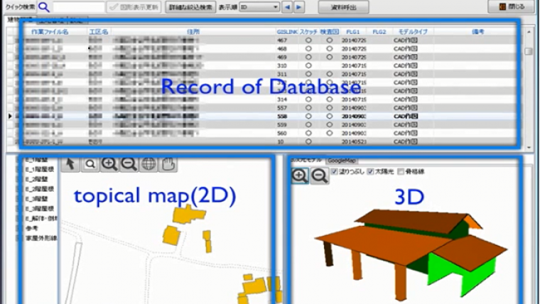
The work of Tsukasa Consulting involves the mass production of detailed, structure-by-structure, 3D maps of decontamination areas by using hybrid 3D vector plotting process with stereographic viewing of aerial imagery. The result is highly accurate, +/- 10cm, 2D and 3D vector objects representing each building structure within a mapped area. The process is cost effective relative to laser scanning methods, taking advantage of already existing data, technology, and knowledge, and resulting in smaller datasets requiring less processing and editing. Bentley Systems MicroStation software is used to generate the 2D and 3D vector models (as DGN files) that are used in the M System software developed using the TatukGIS SDK. The M System solution enables decontamination teams to optimally plan their efforts before entering radioactive zones, know the number of houses in an area, identify structures with contamination, assign personnel to individual houses, and manage the progress using a 3D GIS enabled database system.
The Tsukasa 3D plotting methodology, editing tools, and M System GIS enabled database management software were presented by Tsukasa Consulting, Hamamoto Takashi, at the recent SPAR Japan conference on 3 and 4 June in Kawasaki, Japan. This presentation can be viewed here.
Besides the Fukushima decontamination project, the Tsukasa tools and methodology are targeted to areas including environmental maintenance, architecture, energy (solar panels), prevention and recovery planning of natural disasters, managing of building plans and records, and urban planning.
The image shows The M System 3D mapping application developed from the TatukGIS SDK.

Value staying current with geomatics?
Stay on the map with our expertly curated newsletters.
We provide educational insights, industry updates, and inspiring stories to help you learn, grow, and reach your full potential in your field. Don't miss out - subscribe today and ensure you're always informed, educated, and inspired.
Choose your newsletter(s)


