Global Alliance to Improve Farming Through Remote Sensing
Tetracam and Pix4D have jointly announced a global alliance that combines the technological strengths of both companies to improve farming by means of airborne remote sensing. The alliance is only the latest in a series of strategic partnerships and fast-paced product releases that typify companies producing systems for the rapidly-evolving unmanned aircraft system marketplace.
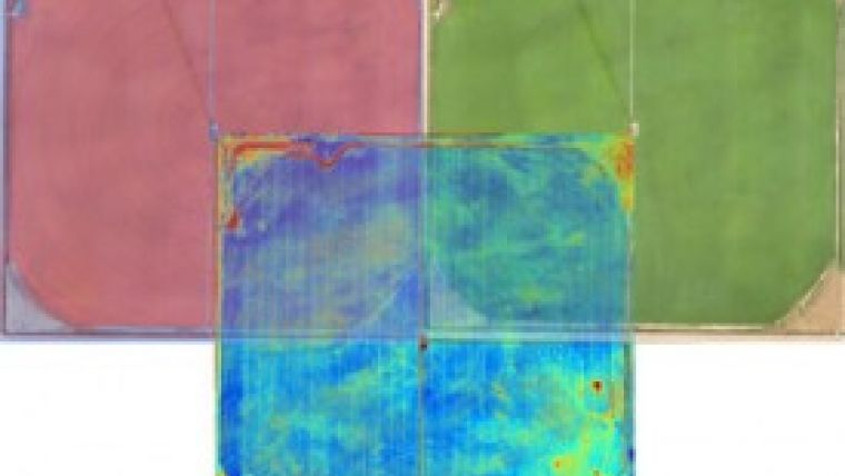
Tetracam, based in California, USA, manufactures multi-spectral imaging systems that monitor visible and near-infrared radiation reflected from agricultural crops and forestlands to spot threats to vegetation from disease, insects, weeds, water shortages, or poor crop management. Most recently, the company introduced cameras that simultaneously look up and down in order to measure reflected radiation as an exact fraction of incident radiation in order to expose subtle secrets hidden in plant bio-chemistry. This month, Tetracam will be releasing the ADC Snap multi-spectral imaging system. This camera uses ultra-high speed snap-sensor machine-vision technology to capture instantaneous images of the ground that are absolutely devoid of camera blur or artifacts that would normally result from aircraft roll, pitch and yaw.
Pix4D, a Swiss company, develops and distributes software that allows users to convert thousands of aerial images taken from manned and unmanned aircraft into two dimensional ortho-mosaics and 3D surface models and point clouds with survey-grade accuracy with centimetre-level precision. The software is highly automated with an intuitive interface. Pix4Dmapper extends the power of Tetracam multi-spectral images by enabling users to derive NDVI, SAVI and less-common vegetation indices used by plant scientists. In most cases, Pix4Dmapper software removes the need for aircraft gimbals and even lens corrective calibration.
Pix4D reseller
In its partnership with Pix4D, Tetracam has become a Pix4D reseller offering reduced prices on Tetracam cameras when bundled with Pix4Dmapper. The company has set up a special technical support engineer to deal with questions from the perspective of the Tetracam system user. The two companies are collaborating on software integration to allow simple importing of images and seamless production of 2D and 3D ortho-mosaics.
Pix4D and Tetracam have already collaborated on presentation of an in-depth 3-day workshop for thirty students in August. The class featured instruction on Tetracam cameras and Pix4Dmapper by experts on the hardware and software from the two companies. The class presented instruction on remote sensing of vegetation by famed research scientist, Dr Dar Roberts of UC Santa Barbara, and practical lessons on integrating and using Tetracam hardware and Pix4D software presented by Scott Brown and Jeff Parisse of CalUAS (located in Ridgecrest, California).
Pix4D and Tetracam have tentatively scheduled another 3-day workshop from 1 to 3 December 2014. For further details on this upcoming workshop or information on Pix4D/Tetracam bundled system sales, send an email to jpalacio@tetracam.com or phone (+1) 818-397-0469.
Image courtesy: Pix4D.

Value staying current with geomatics?
Stay on the map with our expertly curated newsletters.
We provide educational insights, industry updates, and inspiring stories to help you learn, grow, and reach your full potential in your field. Don't miss out - subscribe today and ensure you're always informed, educated, and inspired.
Choose your newsletter(s)


