GPS Technology Key to Traffic Regulation
Diligent adoption of decimetre accurate GPS technology has proved to be the perfect starting point for Wiltshire Council to provide traffic regulation orders in a ‘clear, consistent and transparent’ manner, as directed under the Traffic Management Act 2004.
On 1st April 2009, Wiltshire Council became a Unitary Authority taking responsibility for all aspects of parking. This change reinforced the urgency to complete an exercise in converting parking orders to a map-based system, the communities in the former District of Salisbury being the remaining areas requiring this. The work, entailing the collection of over 10,000 pieces of positional data and 8,000 photographs, was contracted out to Business Management Consultants Gary Kay Smith Ltd through Wiltshire's term consultants.
Wiltshire Council's Traffic Manager, Andrew Wyatt, was already familiar with GPS as a data collection method and aware of the different accuracies of GPS systems available. Following his own research, Andrew Wyatt favoured a higher accuracy survey grade system. Gary Kay Smith Ltd brought further weight to the argument for a system which would be capable of delivering better than 10cm accuracy.
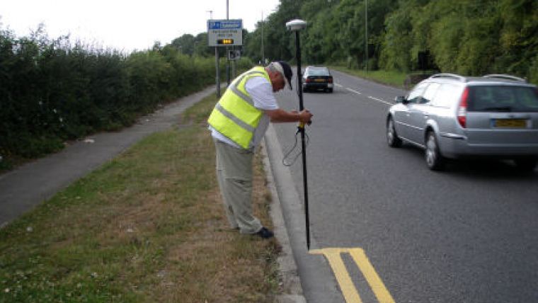
Director Gary Smith explains, "As map-based orders are required to accurately detail the start and finish of restrictions, the method of positioning these details is critical to their end accuracy. Whilst a hand-held mapping GPS could be relied upon to provide 1m accuracy in normal conditions, the City of Salisbury has a compact network of streets with two and three storey buildings on each side which could interfere with satellite coverage. We therefore contacted KOREC, the UK distributor of Trimble GPS, to trial their Trimble R8 GNSS, a survey grade GPS capable of better than 10cm accuracy. By combining the R8 with mapping data collection software, we would have the ideal system for this project."
As the R8 sits on top of a pole, the compact nature of the city streets was no problem. This system also supports GPS and GLONASS signals which means that survey work could continue even in built-up areas with poor sky visibility. Gary Kay Smith Ltd also opted to use Trimble's VRS Now Service to obtain instant real-time corrections in the field, eliminating the need to purchase and set up a base station.
The R8 was used in conjunction with a rugged Trimble Nomad data logger running FastMap Mobile data collection software. This combination enabled field workers from Gary Kay Smith to email collected data at the end of a shift straight to the office where it could be transferred to the Council's corporate GIS, MapInfo and subsequently ParkMap for the creation of map-based traffic regulation orders. The instant transfer of this surveyed data straight to a GIS platform meant that Wiltshire Council could view it immediately and therefore have complete confidence in what had been collected. This would eliminate the need for costly and time-consuming on-site checks.
Using FastMap Mobile also meant that in the office, before the survey, user definable 'attribute definition' lists could be pre-planned to ensure that the maximum amount of relevant data was collected on site.
Additionally, a Ricoh GPS enabled camera was used to photograph all the sign plates. A GPS camera automatically embeds captured images with GPS coordinates for automatic positioning onto a GIS map. These photographs could then be transferred to Google Earth and viewed in context. The GPS camera was also used to collect all the assets in Wiltshire Council's car parks enabling a condition and positional survey to be carried out simultaneously.
For Wiltshire Council, the benefits of opting for a high-accuracy data collection system are clear, up-to-date, accurate, traffic regulation orders that can be easily viewed by members of the public on the council's website, delivering information in a ‘clear, consistent and transparent' way as specified by the Traffic Management Act. The increased confidence Wiltshire Council has in its data means that Appeals at Adjudication can be defended with full trust in the positional accuracy of the signs, lines and traffic regulation orders.
Kay Smith, Director of Gary Kay Smith Ltd, concludes, "Opting for a higher cost GPS has brought this project the all-important accuracy we required, and in fact achieving 5mm accuracy was not unusual. Whilst a number of Local Authorities were losing key Adjudication Hearings due to the poor quality and accuracy of their traffic regulation orders, sign plates and road markings, Wiltshire Council is far better placed to avoid this type of set-back. The success of this work has provided us with the platform to work on similar projects with other Local Authorities."
For more information, visit www.garykaysmith.co.uk and www.korecgroup.com.

Value staying current with geomatics?
Stay on the map with our expertly curated newsletters.
We provide educational insights, industry updates, and inspiring stories to help you learn, grow, and reach your full potential in your field. Don't miss out - subscribe today and ensure you're always informed, educated, and inspired.
Choose your newsletter(s)


