Gulf of Mexico Update: Monitoring Air Quality
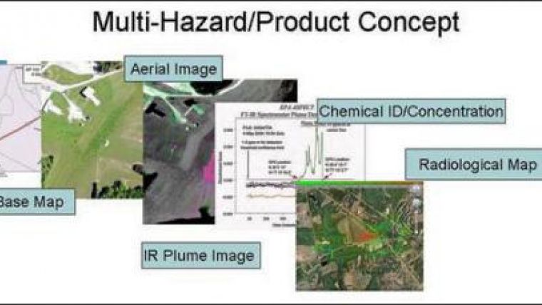
The Environmental Protection Agency is monitoring the air quality caused by the controlled burning of oil slick after the explosion of the BP rig in Block Mississippi Canyon 252 (USA) using a detection plane capable of analysing volatile chemicals: Airborne Spectral Photometric Environmental Collection Technology (ASPECT). Casting about with a combination of airborne photography and infrared spectroscopy, the highly instrumented plane provides emergency responders on the ground with a clear concept of where danger lies, and the nature of the sometimes-invisible plumes that could otherwise kill them. ASPECT is the nations only 24/7 emergency response aircraft with chemical plume mapping capability.
The plane can be in the air in less than an hour with a simple phone call to EPA's National Decontamination Team. ASPECT helps responders image, map, identify, and quantify chemical vapors and plumes. A one half-mile-wide infrared imager coupled with a high speed spectrometer enables plume measurements to be made at a rate of approximately two square miles per minute.
The plane is equipped with a Global Positioning System and uses navigation data to match photographic and infrared information with physical locations. This enabled EPA to find and electronically tag the location of debris as small as one square foot during recovery of the Columbia shuttle wreckage.
ASPECT can also collect radiological data using a high-resolution, multi-crystal gamma-ray spectrometer, supported by high resolution aerial digital photography Data collected are processed on board the aircraft to provide emergency responders with the most current information. Airborne data are ready for dissemination via satellite in less than fifteen minutes after collection.
The aircraft and sensor systems are available 24 hours a day, seven days a week for emergency response. Any EPA onscene coordinator can activate ASPECT. A phone call gets the system into the air in less than an hour.
ASPECT is one of EPA's many time- and cost-effective response tools. It is based out of EPA Region 7's office in Kansas City, Kansas, USA.

Value staying current with geomatics?
Stay on the map with our expertly curated newsletters.
We provide educational insights, industry updates, and inspiring stories to help you learn, grow, and reach your full potential in your field. Don't miss out - subscribe today and ensure you're always informed, educated, and inspired.
Choose your newsletter(s)


