Handheld 3D Scanning of Oxford's Sheldonian Theatre
Researchers from the Oxford Robotics Institute (ORI) have developed a lightweight, handheld device that can create accurate 3D maps of entire buildings in a matter of hours. The device combines five cameras, an inertial measurement unit and a laser scanner into a single unit, which uses simultaneous localization and mapping (SLAM) algorithms to reconstruct the surrounding environment.
The ORI team tested the device by mapping the Sheldonian Theatre, a six-floor, Grade I-listed building in the UK city of Oxford. This took about 30 minutes, compared to four days using a standard 3D laser scanner mounted on a tripod. The data captured by the handheld device was used in the Hilti SLAM Challenge 2022, an annual competition to encourage the development of improved SLAM algorithms.
To produce the 3D maps, the team had to overcome a fundamental problem in robotics and autonomous technologies: SLAM. Associate Professor Maurice Fallon, who leads the Dynamic Robot Systems Group, explained: "SLAM is the computational problem of equipping robots with situational awareness so that they can construct a map of an unknown environment while simultaneously keeping track of their location within it. To map a building quickly, this requires robust algorithms that can combine the sensor and positional data to reconstruct the surrounding environment."
Rapid 3D Scanning
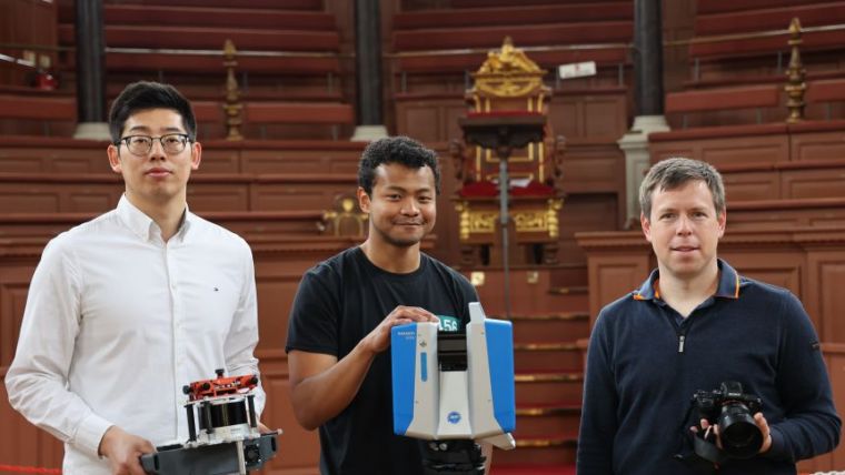
The ORI team have developed a new handheld device that fuses different types of sensors so that their SLAM algorithms can work in many environments. This increases the robustness and accuracy of the resulting 3D model. To test the capabilities of their novel SLAM algorithms, the team partnered with the operations team for the Sheldonian Theatre, which serves as the official ceremonial hall of the University of Oxford. First, the team produced a high-resolution map using a standard survey-grade 3D laser scanner, mounted on a tripod and weighing ten kilograms.
"The disadvantages of the conventional mapping method became immediately apparent," said project lead Lintong Zhang, a DPhil student in the Dynamic Robot Systems group. "Completing the full survey required placing the tripod and scanner in hundreds of different positions, and it was very challenging to manoeuvre it up the narrow staircases. The entire process took four days, during which the theatre had to be closed to the public." In contrast, mapping the Sheldonian with the handheld device took about 30 minutes: the time required to walk around the building.

Value staying current with geomatics?
Stay on the map with our expertly curated newsletters.
We provide educational insights, industry updates, and inspiring stories to help you learn, grow, and reach your full potential in your field. Don't miss out - subscribe today and ensure you're always informed, educated, and inspired.
Choose your newsletter(s)


