Historical Demography in GIS
SuperGeo Technologies is developing a WebGIS system that allows users to view the population structure at a specific time in a specific area. The platform assists scholars in population comparison between different areas or different times via the Internet.
As the historical demographic data is a crucial base for understanding the population structure in the past time, the Research Center for Humanities and Social Sciences, Academia Sinica, started to establish the Taiwan Colonial Household Registration Census Database in 2005, aiming to provide users with the service to view the household registration census of each administration area in the Colonial Period online and expand the studies of population change and the related social sciences.
In 2010, in order to promote and meet the needs for the studies of historical population, the Historical Demography GIS is developed with the architecture of Taiwan Economic and Social Indicator GIS as the foundation to provide the scholars with a tool to explore the historical demography from the aspect of space.
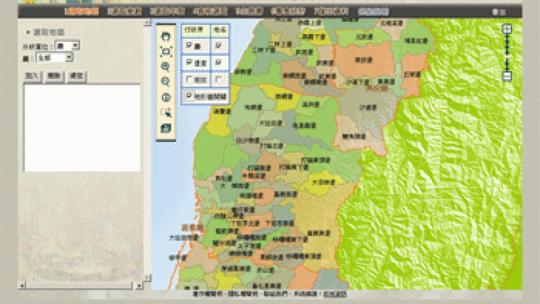
Taiwan Historical Demography GIS is a WebGIS based system for querying historical demographic data of Taiwan. This Web-GIS applies SuperWebGIS as the map server platform to publish maps and historical demographic data of Taiwan via the Internet. Client users can obtain the needed data through the Internet in a convenient way.
This project uses two servers, including database server and application server (AP server). The AP server is set up in the demilitarised zone (DMZ), between intranet and Internet, protected by a firewall. Consequently, even if it is damaged by outside attack it can be reconstructed in a short time and the important data still can be saved.
In terms of functions, five categories of functions are provided in Taiwan Historical Demography GIS, including Map Display and Basic Manipulation, Data Search, Draw the Thematic Map, Draw Statistics Chart, and Export Data and Layer.
In the future, the system will use historical demographic data as the foundation to further expand the domains of land survey, hygiene, medical care, social economic, etc., expecting to develop historical geography, sociology, economic history, etc.

Value staying current with geomatics?
Stay on the map with our expertly curated newsletters.
We provide educational insights, industry updates, and inspiring stories to help you learn, grow, and reach your full potential in your field. Don't miss out - subscribe today and ensure you're always informed, educated, and inspired.
Choose your newsletter(s)


