Hottest-ever Topographic UAV Survey in Abu Dhabi Desert
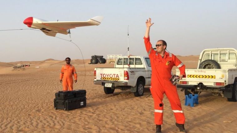
Skeye from The Netherlands and Fugro Maps recently completed an aerial topographic survey using a fixed-wing UAV in the desert south of Abu Dhabi in the United Arab Emirates. Fugro’s client insisted on rapid project execution meaning that the survey was carried out in the middle of summer. With measured temperatures in the sun of up to 68 degrees Celsius this must be one of the hottest UAV surveys ever conducted.
The area to be surveyed was approximately 15km2 and consisted entirely of sand dunes in the desert. The reason for the survey is future industrial development. Skeye and Fugro obtained permission from the UAE General Civil Aviation Authorities to operate an unmanned fixed-wing UAV equipped with a camera over the area. Skeye choose to deploy the Hawk-Eye fixed-wing aircraft in a white body so as to minimise overheating of the components during the survey.
Desert training procedures
The team deployed to the desert consisted of two cars, two quad all-terrain bikes, drivers, surveyors and a pilot, all mobilised to a base at about one hour's drive from the survey area. The drivers and all the crew had followed special desert training procedures to ensure the safety of the team. An ample supply of drinking water proved to be crucial as the Skeye pilot alone consumed over two litres per hour. The first task on the ground was the installation of the ground control markers and measuring these using RTK GPS. More than 60 ground control points were installed and a few hundred verification measurements were made for quality control purposes.
The UAV flights in the heat proved to be a real challenge. The Hawk-Eye UAV had to be cooled using the air-conditioning inside a car prior to take off. The loading of the flight plan and some other checks also had to be done in the car. The UAV had to be launched within a couple of minutes of it being taken out of the car. During the flight the drone was cooled by the air flowing around it.
4,100 images were collected in a special pattern to ensure sufficient overlap for photogrammetric calculations. From the images a point cloud, a 3D digital terrain model (DTM) and one seamless orthophoto-mosaic were produced.

Value staying current with geomatics?
Stay on the map with our expertly curated newsletters.
We provide educational insights, industry updates, and inspiring stories to help you learn, grow, and reach your full potential in your field. Don't miss out - subscribe today and ensure you're always informed, educated, and inspired.
Choose your newsletter(s)


