How the geospatial industry is embracing AI
In the past, artificial intelligence has often been misused as an umbrella term to the point where it was at risk of becoming an overhyped buzzword. But as the technology has matured and real-life applications have become apparent, the geospatial industry is embracing it and AI is already part of many geospatial solutions. This is also reflected in this selection of articles.
"Artificial intelligence is definitely not just a hype"
“One strong ‘trend’, if we can call it that, in the years ahead will be automatic object recognition in 3D point clouds. Artificial intelligence (AI) is definitely not just a hype. At Geomaat, we are using it more and more in conjunction with automatic object recognition in point clouds. The challenge is to deploy this valuable technique effectively."
How geospatial AI leads to smart urban ecosystems
The use of satellite imagery to manage the health of trees in cities improves urban ecosystems. By combining traditional methods with other geospatial technologies, such as remote sensing, and artificial intelligence to achieve ‘geoAI’, it is possible to detect and classify features even faster and more accurately. GIM International spoke to Dr Nadina Galle, an award-winning ecological engineer and entrepreneur dedicated to applying emerging technologies, to learn more about the seemingly limitless possibilities of geoAI.
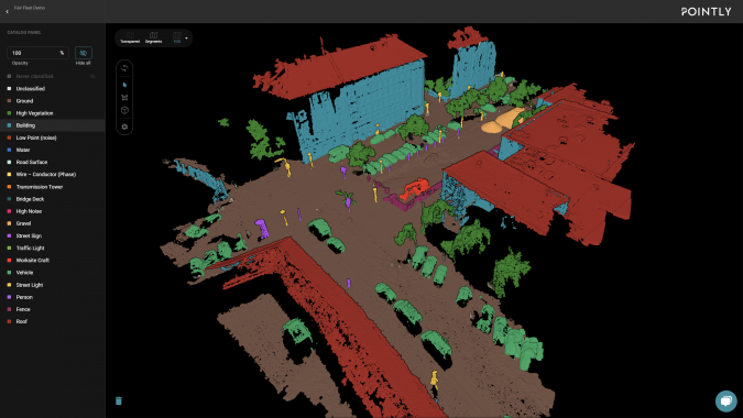
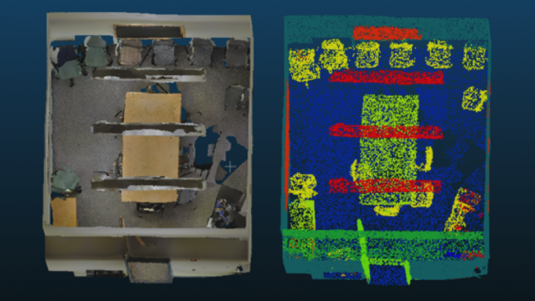
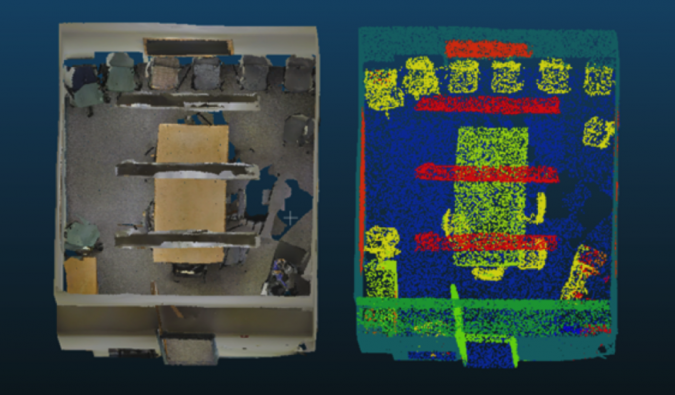
Digitizing reality: automated 3D point cloud data processing using AI
How can today's advanced technology solve the challenges that many organizations face after obtaining vast 3D point cloud datasets, such as the management, storage, registration, fusion and extraction of useful and actionable information?
Building a digital twin for Germany
The German Federal Agency for Cartography and Geodesy (BKG) is creating a digital twin of Germany that can be used to simulate various future scenarios in order to adequately address societal challenges, such as the increasing use of land, rising energy demands and extreme weather. This digital replica of Germany will be built as an intelligent 3D world containing all the essential geospatial objects, enabling the relevant processes to be mapped holistically and in relation to each other based on a common data foundation. This is intended to support faster, more informed and more reliable decision-making.
How to capitalize on the opportunities in the golden era of geospatial
“AI is at the centre of data analytics and, since geomatics deals with spatial data, AI should be seamlessly incorporated in geomatics. In other words: high-end geospatial technology, imagery and artificial intelligence converge and are melting together in GeoAI”.

Value staying current with geomatics?
Stay on the map with our expertly curated newsletters.
We provide educational insights, industry updates, and inspiring stories to help you learn, grow, and reach your full potential in your field. Don't miss out - subscribe today and ensure you're always informed, educated, and inspired.
Choose your newsletter(s)


