Intermap Signs Comprehensive Geospatial Services Agreement with Dewberry
Intermap Technologies has signed a new Master Services Agreement with Dewberry under its recently awarded U.S. Geological Survey (USGS) Geospatial Products and Services (GPSC4) prime contract. Intermap – a global leader in geospatial content development and intelligence solutions – has been a subcontractor on the USGS GPSC contracts since 2010, collecting, processing and delivering Lidar and IFSAR elevation data in support of the USGS 3D Elevation Program (3DEP).
3DEP is managed by the USGS National Geospatial Program to respond to growing needs for high-quality topographic data and for a wide range of other 3D representations of natural and constructed features across the country. 3DEP informs critical decisions that are made every day that depend on elevation data, ranging from immediate safety of life, property and environment to long-term infrastructure planning.
Elevation data collection and processing
The 3DEP initiative is based on the results of the National Enhanced Elevation Assessment (NEEA), which was funded by the National Digital Elevation Program (NDEP) agencies and completed in 2011. The study, led by the USGS, identified more than 600 requirements for enhanced 3D elevation data to address mission-critical information requirements of 34 federal agencies, all 50 states and a sample of private-sector companies and tribal and local governments.
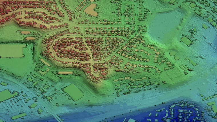
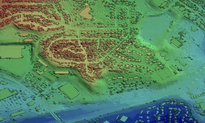
The USGS GPSC contracts comprise a suite of agreements used by federal, state and municipal government entities to partner with the USGS to fulfill their geospatial data requirements. This new contract includes elevation data collection and processing, hyperspectral and multispectral remote sensing, airborne geophysical surveys and the production of elevation-derived hydrography for updating the National Hydrography Database (NHD). The NHD is part of the USGS 3D Hydrography Program (3DHP) and will provide high-resolution data representing water flowlines and estimating stream flow volume and velocity. Intermap brings new advanced machine learning and AI-enabled automation to the vector modelling and analysis requirements for the programme. The Company's data collection and processing capabilities provide high-quality elevation products to produce a digital twin of an area's terrain, enabling a wide range of market use cases. The GPSC4 has a total contract value of US$850 million and will run through February 2027 if all annual options are exercised.
Orthorectified radar imagery
The GPSC contracts are used to facilitate interagency cooperation to address a broad range of geospatial needs. When the State of Alaska required updated statewide elevation data, Dewberry subcontracted with Intermap to provide USGS and partner agencies with an IFSAR solution to meet stringent accuracy requirements across the vast, remote, and often cloud-covered area. Over the course of 10 years, Intermap was tasked by Dewberry via the USGS GPSC with collecting and delivering seamless 5m digital elevation models and cloud-free 62.5cm orthorectified radar imagery for over 1,150,000 square kilometres, representing 78% of Alaskan territory. Intermap's deliverables consistently exceeded all contract specifications, on time and under budget, bringing Alaska's outdated state maps up to national mapping standards. These data are now being used to improve the economy, quality of life and safety of all Alaskans, while satisfying needs for flood modelling, flight safety, environmental monitoring and climate change analysis and adaptation in America's last frontier.
Between 2010 and 2020, under the USGS GPSC2 and GPSC3 contracts, Intermap was awarded with 26 Task Orders for Lidar and IFSAR data collection and processing with the total value of all task orders exceeding US$42 million.
"Intermap is proud of our longstanding partnership with Dewberry and the USGS and pleased to continue providing the best airborne IFSAR data in the world," said Patrick A. Blott, Intermap's chairman and CEO. "Our extensive past experience collecting, processing and delivering geospatial data for national mapping initiatives positions us well to meet the needs of this major contract. We look forward to bringing enhanced IFSAR collection capabilities and geospatial analytics to Dewberry's GPSC4 team."

Value staying current with geomatics?
Stay on the map with our expertly curated newsletters.
We provide educational insights, industry updates, and inspiring stories to help you learn, grow, and reach your full potential in your field. Don't miss out - subscribe today and ensure you're always informed, educated, and inspired.
Choose your newsletter(s)


