iOS Mapping Solution Enhances Raster Data Support
Supergeo has released the latest update of SuperSurv 3.2 (iOS) to enhance the functionality and efficiency for mobile GIS surveyors. According to the provider of GIS software, this version has a stronger compatibility with raster datasets and convenient tools for data display, collection and query, helping users to conduct field work with ease and more productivity.
SuperSurv is a mobile GIS App designed for field data collection on iOS and Android powered platforms. Integrating with GIS and GPS technologies, SuperSurv provides the functions like map display, query, measure, etc., and supports to overlay OpenStreetMap as the basemap. Users can also capture point, line and polygon features and attribute data, and save the data as SHP or GEO format in both offline and online modes.
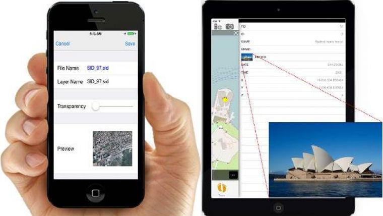
The latest SuperSurv 3.2 directly supports raster dataset, MrSID and JPEG 2000, as basemap, and increases the capability to load various raster files within one project. As for map display, OpenStreetMap auto-scaling function is now offered by using the current position as a reasonable range, bringing more efficient usage of online map projects.
The newly developed function, Screen Lock, will be applied automatically while users start collecting data via GPS, helping field workers prevent unintentional mistakes during operation. Moreover, the renewed previewing, importing as well as querying functions of multimedia will also provide users with a smoother user experience.

Value staying current with geomatics?
Stay on the map with our expertly curated newsletters.
We provide educational insights, industry updates, and inspiring stories to help you learn, grow, and reach your full potential in your field. Don't miss out - subscribe today and ensure you're always informed, educated, and inspired.
Choose your newsletter(s)


