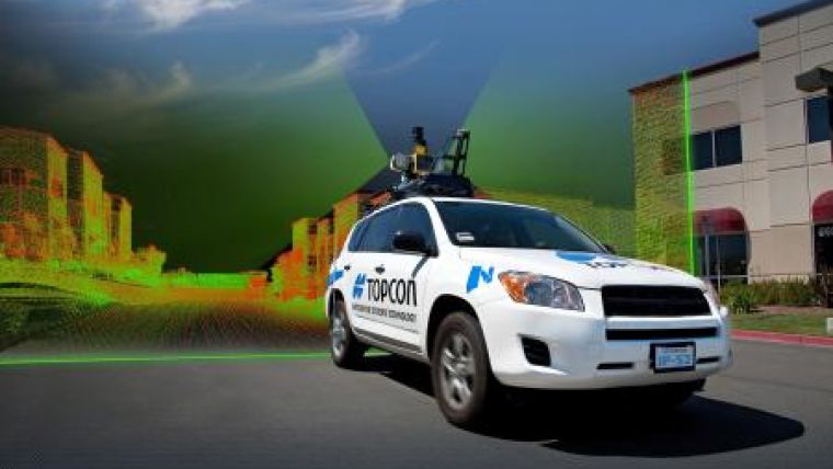
IP-S2 HD Mapping System
The IP-S2 HD Mapping System is a vehicle-mounted surveying and mapping system featuring a high-definition Lidar scanner from Velodyne Lidar. The IP-S2 HD Mapping System incorporates Velodyne's HDL-64E S2.2 Lidar scanner, allowing vehicle operators to acquire very dense point clouds while travelling at posted speed limits even in inclement weather.
Velodyne Lidar is a manufacturer of high-definition Lidar sensors, headquartered in Morgan Hill, California. The company's HDL-64E sensor is used in a variety of military and commercial autonomous vehicle applications as well as 3-D mapping, surveying and other applications.
"Velodyne is very excited that Topcon has integrated our HDL-64E S2.2 sensor with the IP-S2 HD Mapping System," said Bruce Hall, president of Velodyne. "With the HDL-64E's dense point coverage which outputs at over 1.3 million points per second, 64 lasers, full 360 degree field of view, and road-tested design, the system can collect data even in poor weather conditions. The IP-S2 HD Mapping System can capture data at highway speeds up to 70 miles per hour and its return on investment, compared to manual data collection methods, is realised in just a few months."
Dave Henderson, TPS 3D mobile mapping national sales manager said, "With the IP-S2 HD, a single crew with a single user-supplied vehicle can acquire a complete dataset while driving, providing a revolutionary mobile data collection solution. Geo-referenced spatial data and colourful imagery allows users to easily identify features, assign attributes and export data to various CAD and GIS applications.
"The IP-S2 HD increases safety by eliminating the risk of working in busy streets and highways, and allows for more coverage and increased productivity compared to traditional methods. Users gain additional cost savings as the initial dataset can be accessed as frequently as needed and features can be extracted at any time, eliminating time-consuming returns to the field," Henderson said.

Value staying current with geomatics?
Stay on the map with our expertly curated newsletters.
We provide educational insights, industry updates, and inspiring stories to help you learn, grow, and reach your full potential in your field. Don't miss out - subscribe today and ensure you're always informed, educated, and inspired.
Choose your newsletter(s)


