Ireland's diverse landscapes revealed in new National Land Cover Map
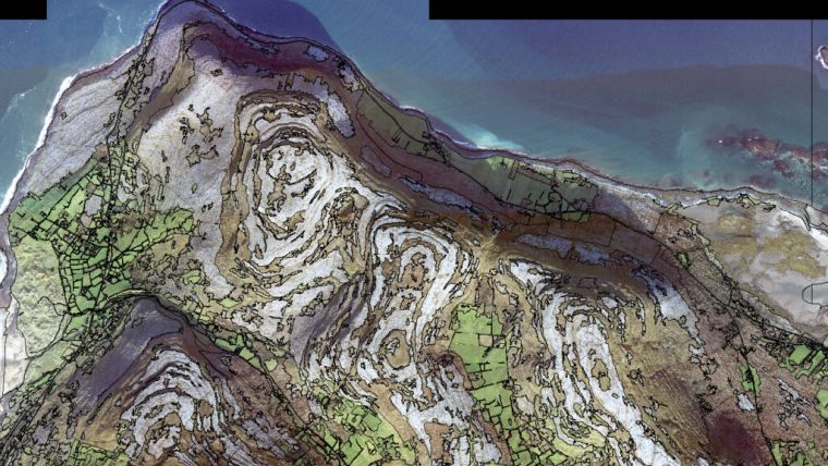
The UK's Environmental Protection Agency (EPA) and Tailte Éireann (formerly known as the Ordnance Survey of Ireland) have collaborated to launch a groundbreaking National Land Cover Map of Ireland. The map categorizes over 10 million landscape features, providing detailed information on land cover types across the country.
Produced by the National Mapping Division of Tailte Éireann in partnership with the EPA, the map is the first of its kind in Ireland. It combines existing land cover data with remote sensing methods, aerial images and satellite images to map what is physically present on the Earth's surface, including natural vegetation, freshwater and non-living surfaces such as forests, grasslands and artificial areas.
The National Land Cover Map represents a significant improvement in land evidence and will have numerous applications in environmental assessments related to water, climate, air, noise and biodiversity. It is expected to be a valuable resource for many years to come.
Overall, the launch of the National Land Cover Map of Ireland is a major milestone in the country's efforts to promote environmental protection and sustainability. The map was created using data from 2018 and provides a detailed overview of the different types of land cover in Ireland.
36 land cover classifications
It is important to distinguish between land cover and land use. Land use refers to the purpose for which land is used, such as environmental, economic or social activities, which are typically the result of human intervention or management. On the other hand, land cover refers to the physical composition of the Earth's surface, including natural features like forests and grasslands, as well as human-made structures like roads and buildings.
The National Land Cover (NCL) 2018 map was produced based on data from 2018 and includes 36 different land cover classifications that reflect the unique and diverse landscapes of Ireland. This information will help government agencies, public sector bodies and commercial organizations to better understand the environmental challenges posed by development, habitat loss and climate change, and to focus on sustainable land management.
According to Laura Burke, director general of the EPA, the NCL map produced by Tailte Éireann and the EPA will facilitate improved monitoring and assessment of the impacts and benefits of water, climate, air, noise and biodiversity, and provide support for better decision-making on land management. The map represents a significant step forward in Ireland's efforts to promote environmental sustainability and preserve its natural resources.

Value staying current with geomatics?
Stay on the map with our expertly curated newsletters.
We provide educational insights, industry updates, and inspiring stories to help you learn, grow, and reach your full potential in your field. Don't miss out - subscribe today and ensure you're always informed, educated, and inspired.
Choose your newsletter(s)


