Landins to Improve Mobile Scanning
ABA Surveying has selected a LANDINS inertial navigation system (INS) to provide the vital position and orientation data required by its kinematic mapping system. Just over a year ago, ABA set out to develop a survey/mapping system that could be installed in a road vehicle and hence used for a variety of highways, civil engineering and urban architectural applications.
ABA has vast experience of this kind of survey and mapping work in the railway industry, where such surveys are uniquely carried out by them using rail trolleys. In this case, the scanning platform is very stable and there is a perfect trajectory - the track itself - on which to hang the scan data. On the roadway, however, those trajectories are lost and scanning systems become heavily reliant on positional information provided by global navigation satellite systems (GNSS). In urban environments containing buildings, bridges, trees, road cuttings and so-called urban canyons, GNSS performance is significantly degraded, and information can sometimes be lost altogether. An INS system is therefore needed to qualify the GNSS data and to reverse compute the scanner trajectory during GNSS outages.
Alan Barrow, ABA Surveying's founder, said: "The choice of INS was made after much careful evaluation and experimentation. Our aim was to develop a scanning system with an absolute accuracy of better than 10mm when being used at highway speeds. There are only a handful of suppliers offering high-end systems that are capable of achieving the results we were looking for."
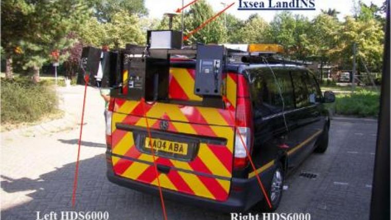
ABA's mobile scanning system is contained in a "scan-van" and principally comprises three Leica 6000 scanners, GNSS geodetic quality receivers (selected for their sensitivity and ability to rapidly re-establish their position after a break in the signal), a LANDINS unit, an advanced data logger and a rack-mounted computer based on an i7 processor for systems control and monitoring. The whole system is operated from a conventional keyboard and two 20-in flat-screen monitors in the back of the van.
IXSEA developed LANDINS specifically for land-based mobile applications in urban environments where GNSS data are of limited quality. The units provide highly-accurate positional information in real time with precise timings and very high output rates. Their open architecture also means they are easily integrated with other survey/mapping system components.
From a practical standpoint, LANDINS raises the survey/mapping performance of mobile 3D laser scanning systems into the realm of that achieved by static scanning systems. Survey speed is obviously significantly increased and there are safety advantages: operators do not need to be positioned in road lanes and there is no disruption to traffic.

Value staying current with geomatics?
Stay on the map with our expertly curated newsletters.
We provide educational insights, industry updates, and inspiring stories to help you learn, grow, and reach your full potential in your field. Don't miss out - subscribe today and ensure you're always informed, educated, and inspired.
Choose your newsletter(s)


