Leica Captivate Releases Touch-technology Software with Self-learning Measurement
This article was originally published in Geomatics World.
Leica Geosystems released the revolutionary touch-technology software Leica Captivate today within the world’s first self-learning MultiStation and total stations.
Creating the most realistic 3D models, the Leica Captivate experience enables measurement professionals across a wide array of industries working in various applications to capture and manage complex data easily and accurately. Combining engaging software, precision measurement instruments and trusted services creates an all-encompassing solution and a new concept in user experience.
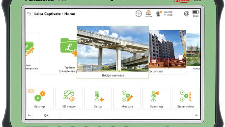
Leica Captivate offers a revolutionary way to interact with any work data in the field or office. With little more than a simple swipe, users can now navigate through customisable apps containing information for multiple projects. Advanced lining and coding come together to provide an interactive 3D model where users can zoom, pan and orbit the rendering for optimal viewing and manipulation.
ESE Consultants Assistant Regional Director of Surveying Shawn Crawford, a professional land surveyor with more than 20 years of experience in the field, recently spent his free time beta testing Leica Captivate on the new Leica CS20 controller. He simulated field work such as traversing, line coding, 2D and 3D stakeouts, resections, GPS localisations, alignments, stake to DTM, as well as software functionality. Crawford found the new software and controller to offer an “amazing” experience.
“As a consumer, I appreciate how Leica Geosystems reached out and listened to what is important to us. So, of course, I was interested and very honoured to participate in beta testing Captivate. I believe Captivate will be a gamechanger in the market; there is simply nothing like it. The ability to view and survey inside a 3D scan; it's very impressive as well as valuable for surveyors to have this technology.
“Leica Geosystems has taken a giant leap forward with Captivate by resembling a smartphone look and feel. With scrolling apps you can customise and prioritise in any order you like. The job carousel allows you to attach photos to job files to make it easier to identify each project, and with a click of the job file, you're quickly transitioned to a menu that allows you to view and edit the data and properties. Simple things like these are what make Captive such an enjoyable experience."
With Leica Captivate onboard, the new Leica total stations and MultiStation are optimised with the fifth generation of ATRplus. These precise instruments increase efficiency and make work faster with the ability to ignore all distractions in the field and remain locked onto the sole target. They learn any environment, deliver accurate positions regardless of the most difficult conditions, and offer the fastest relock in case of interrupted line of sight.
The new instruments include: Leica Nova MS60 MultiStation; Leica CS20 Controller; Leica Nova TS60 Total Station; Leica CS35 Tablet; Leica Viva TS16 Total Station.
When integrated with the Hexagon Imagery Program through Leica Infinity office software, high-quality basemaps are able to be viewed in Leica Captivate. This 30 centimetre, 4-band georeferenced imagery helps users be more visually aware of what is in any jobsite, allowing for better decision making in real time for increased productivity, fewer errors and decreased return trips to the site and saves time during post-processing.
Leica Infinity, also optimised in the release of Leica Captivate, now delivers enhanced workflows by supporting the new field software. With a simple user interface, Leica Infinity (v1.3) gives a perfect project overview by combining multiple scans to create information-rich surfaces. Leica Infinity offers a wide range of options for project data processing for multiple CAD and BIM software packages, making decision making easier and more cost efficient.
Further information about the Leica Captivate Experience can be found at: http://www.leica-geosystems.com/becaptivated

Value staying current with geomatics?
Stay on the map with our expertly curated newsletters.
We provide educational insights, industry updates, and inspiring stories to help you learn, grow, and reach your full potential in your field. Don't miss out - subscribe today and ensure you're always informed, educated, and inspired.
Choose your newsletter(s)


