Lidar Point Cloud Models Visualized in 3D-Stereo
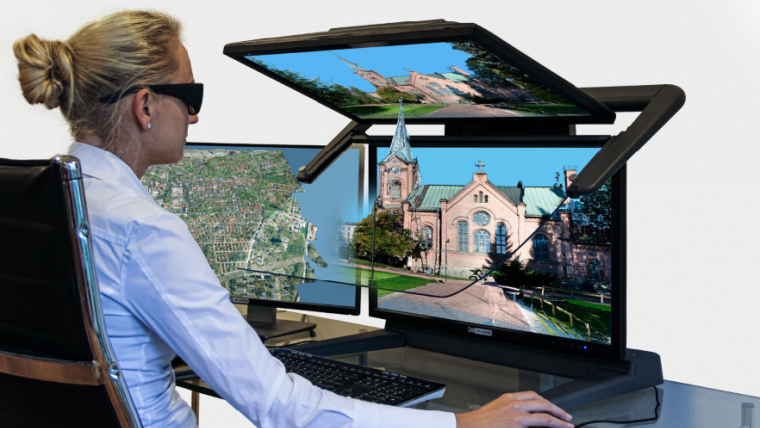
For consistent and precise digital GIS and photogrammetry workflows, raw data must first be converted into integrable and thus valuable information components that meet the requirements of the respective application environments. The 3D point cloud processing modules from the Finnish software provider Terrasolid are highly developed, intelligent and powerful applications. For the spatial viewing and measurement of 3D models, TerraStereo relies on the detailed high-contrast 3D-stereo display of passive, double-screen beamsplitter systems, the 3D PluraView series from Schneider Digital.
Terrasolid’s solutions are able to process and model laser points with their XYZ coordinates at high speed and can also display the result in 3D-stereo. During the last 20 years, the capabilities of the available Lidar hardware has developed rapidly together with the capabilities of the processing software, with Terrasolid applications at the forefront.
Rapidly Advancing Lidar Technology
The variety of Lidar applications has developed rapidly within just a few years: surveyors and civil engineers use 3D point clouds for terrain modeling, for the construction and monitoring of bridges, dams, high-voltage power lines, as well as for determining the quality of road surfaces, for high-precision measurement with millimeter accuracy of railway tracks and the entire railway infrastructure. City planners receive very precise information about the existing vegetation in cities, and precise reference points for building measurements are recorded at the same time. Archaeologists use precise and RGB-textured Lidar data to record and reconstruct important cultural monuments. Recently, following the massive fire at Notre-Dame, the medieval church in the center of Paris, the remaining structure was completely surveyed with high-resolution Lidar instruments. These are just a few examples for the use of Lidar data, data that has been processed for many years with the versatile and constantly further developed Terrasolid application tools.
Use cases develop due to the increasing diversity and rapid development of Lidar data acquisition scanners. Very small but precise airborne laser scanners are available for Unmanned Aerial Systems (UAS), often also referred to as 'drones'. In larger, single or twin-engine aircraft, very powerful Lidar instruments are used for greater altitudes and for covering large areas. On the ground (terrestrial), Lidar data acquisition begins with very small scanners that are hand-held and are therefore ultra-mobile, or – somewhat larger and very precise – laser measurement heads installed on tripods with a range of several hundred meters. These are used in combination with digital cameras, often mounted on vehicle roofs, for fast, mobile Lidar data acquisition.
Visualizing Lidar Point Clouds in 3D-stereo
The dual-screen, stereoscopic 3D PluraView monitors from Schneider Digital visualize these point clouds in the highest 3D-stereo display quality and are ‘plug & play’ compatible with the TerraStereo software by Terrasolid. Users benefit from flicker-free, pixel-precise visualization with resolutions of up to 4K per screen and eye. The 3D PluraView monitors are the perfect visualization solution for comfortable work with high-resolution Lidar data in all 3D-stereo and VR / AR desktop application areas. The compatibility of TerraStereo with the 3D PluraView monitor family has now been officially certified by the manufacturer Schneider Digital.
The Lidar applications from the Finnish software company Terrasolid are the world's leading platform for the processing and visualization of point clouds. As a company, Terrasolid has been successfully established in the geodata market for more than 30 years and has been the global market leader specifically with Lidar software solutions – such as TerraScan, TerraModeler, TerraMatch, TerraPhoto and TerraStereo – for more than 20 years now. Independent of Lidar data sources and sensors, Terrasolid offers versatile and powerful tools for the editing of 3D point clouds, feature extractions, terrain representations and point cloud visualizations. With TerraStereo, even very large point clouds with more than 50 billion points can be realistically visualized in 3D-stereo at very high speed with freely selectable point textures.
Visualize, Analyse, Calculate and Extract Lidar Data
TerraStereo is specifically tailored for the 3D-stereo visualization of data from every Terrasolid workflow and can be combined with all other Terrasolid software products. The workflow with software products from the Terrasolid family usually begins with TerraScan. TerraScan manages, processes and visualizes all types of point clouds. The application offers various import and project structuring tools for very large amounts of data. With this powerful tool, complex buildings, landscapes as well as road and cable networks can be reliably measured, vectorized and precisely modelled in 3D. In combination with additional Terrasolid applications such as TerraModeler, TerraMatch, TerraPhoto, TerraSlave and other products, users have all the tools at their command for the highly automated processing of Lidar point clouds and the creation of 3D vector datasets. TerraStereo offers the possibility to visualize buildings, topographies and entire railway and tram infrastructures in 3D-stereo. The software application is used for instance to visualize power lines, visualize corridor analysis, represent dangerous objects in 3D-stereo and enables the efficient visual representation of road surface conditions for risk assessment.
Terrasolid's software products combine the processing of Lidar and RGB-I image data from terrestrial and airborne laser scanning systems. Terrasolid is neither limited to certain data applications nor to specific laser scanning or camera systems. From calibration to comparing and merging of input data to the creation of final 3D vector models, ortho-images with TerraPhoto, terrain representations with and without natural vegetation, the software applications are highly flexible and offer powerful solutions, e.g. for surveying and construction, cartography, photogrammetry and surface analysis, but also for archeology, research and urban development. TerraScan converts every point cloud precisely, quickly and in high quality into a corrected 3D model or to CAD vector elements, which saves time and money and optimizes workflows. Fast data export is a great advantage, for example in smart city and urban planning applications that are being used on desktop, mobile and web platforms.
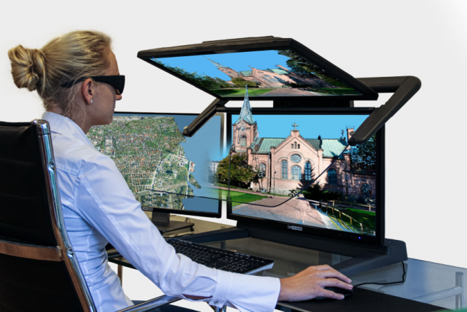
When it comes to spatial viewing and measurement of 3D models, the TerraStereo software solution depends on the detailed, high-contrast 3D-stereo display of passive, double-screen beamsplitter systems, the 3D PluraView series from Schneider Digital. These high-end displays are the de-facto industry standard for all stereo-capable Lidar, photogrammetry and GIS applications. The color representation of RGB-textured point clouds is an experience on its own on the powerful and innovative 3D-stereo display systems from Schneider Digital. With a very sharp display in real time, they are completely flicker-free and can be used ‘plug & play’ for all TerraStereo functionality, such as precise 3-axis measurement in 3D space.
Intelligent Point Clouds
With screen diagonals up to 28 inches, the 3D PluraView monitors deliver highly detailed, stereoscopic 3D visualizations. Thanks to one monitor per eye, they offer up to 4K stereoscopic resolution and brilliant image brightness. Their optimal ergonomics and passive polarization filter technology ensures fatigue-free work, also in normal daylight office conditions. Not only Terrasolid users appreciate the easy handling of the 3D PluraView monitors: 3D models can be easily displayed and easily measured or edited with a 3D mouse. Terrasolid users benefit from mature 3D visualization technology with the 3D PluraView monitors, established throughout the geospatial industry for many years.
Together with the high-end displays from Schneider Digital, professional users of the high-performance Terrasolid software suite get a complete package that is fine-tuned at the highest level. Measuring, capturing, analysing and visualizing 3D data is not only convenient with these combined and innovative technologies, it also adds real to any demanding GIS workflow. For this reason, Schneider Digital has now officially certified TerraStereo for 3D-stereo visualization with its 3D PluraView monitors.

Value staying current with geomatics?
Stay on the map with our expertly curated newsletters.
We provide educational insights, industry updates, and inspiring stories to help you learn, grow, and reach your full potential in your field. Don't miss out - subscribe today and ensure you're always informed, educated, and inspired.
Choose your newsletter(s)


