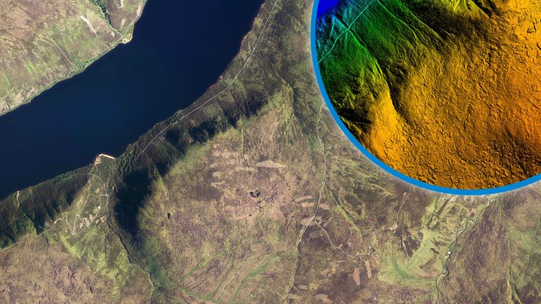
Lidar Used to Visualize Land Restoration on Queen Elizabeth’s Balmoral Estate
Data collected from survey aircraft equipped with advanced laser scanners is being used by the James Hutton Institute to monitor the natural restoration of land at the Queen’s Balmoral Estate in Scotland. Lidar data supplied by aerial mapping company Bluesky is being used to create highly detailed 3D models of upland peatland in order to monitor changes in hydrological and waterflow dynamics as a result of restoration work. The Lidar data will also be used to identify areas of vegetation and bare peat and cost future restoration projects.
“Water catchments in peatland areas are notoriously difficult to determine as the terrain is, surprisingly, so flat!” commented Gillian Donaldson-Selby, a PhD Student and landscape visualizer at the James Hutton Institute. “Traditional models created from stereo aerial photography do not offer the level of detail and accuracy required for these types of landscape so to support the fine-scale modelling we are planning we turned to Bluesky and their high-resolution Lidar.”
The James Hutton Institute is a well-respected and globally recognized research organization which uses science to drive the sustainable use of land and natural resources. The Institute has been monitoring carbon fluxes at the Balmoral site, which has been highly eroded, for some time. The site, which is currently undergoing restoration by the Cairngorms Park Authority and NatureScot: Peatland Action as part of the Scottish Government 250 million GBP peatland restoration programme, presented an opportunity to monitor various aspects of the restoration success.
Bare earth and surface features
Captured during a single flight using an aircraft mounted Lidar sensor, Bluesky recorded 25 points per metre across the site recording both the bare earth and surface features to an accuracy of 12 centimetres. The data, sitting alongside other resources including measurements from hydrological and meteorological field equipment, was processed using a combination of Global Mapper GIS (Geographical Information System) and a hydrological modelling product MIKE SHE. Visualizations of the site were also produced with Visual Nature Studio for use in research papers, at conferences and in journal articles.
The Bluesky data will also support analysis to identify specific areas of vegetation and bare peat whilst NatureScot, which has helped fund the survey, is keen to use the outputs to identify and cost future restoration needs. Project partners the Cairngorms Park Authority, who are taking the lead on restoration, hope to use the Lidar data to monitor and map progress and in the long term it is hoped it will be a useful tool to assess the efficiency of work to date.

Value staying current with geomatics?
Stay on the map with our expertly curated newsletters.
We provide educational insights, industry updates, and inspiring stories to help you learn, grow, and reach your full potential in your field. Don't miss out - subscribe today and ensure you're always informed, educated, and inspired.
Choose your newsletter(s)


