London Borough Creates Digital Twin with Street Imagery and Lidar
The London Borough of Harrow has added high-definition street-level imagery and Lidar data to its Esri UK corporate GIS system, giving staff access to a highly accurate digital twin of the borough. As part of Harrow’s strategy to explore new digital approaches and advance its digital twin agenda, the move is designed to improve the efficiency of various tasks in planning, highways and council tax and reduce the overall need for physical site visits.
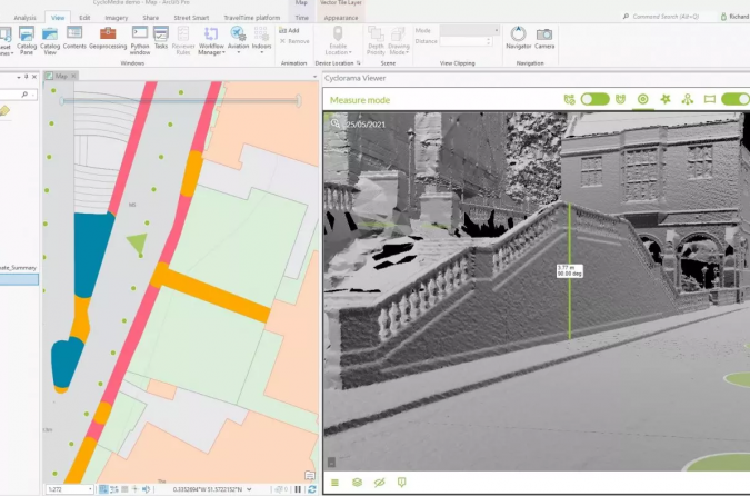
As Esri UK partner, Cyclomedia provides the new imagery and associated Lidar data provides a full-3D digital representation of the environment and can be viewed simultaneously alongside other geospatial data within the Esri GIS, such as street furniture, council tax records, planning applications and Ordnance Survey data.
The new imagery will mean Planning can view properties alongside planning applications, Highways can verify that street works have been delivered or plan new mobility schemes, such as cycle lanes, while the Council Tax department can carry out remote property inspections. Users can also apply the various analysis tools within the Esri GIS system to the imagery, such as accurate measuring of properties or boundaries and viewshed analysis, to determine where shadows may fall from future developments, for example.
The many advantages of imagery along with Lidar data
Harrow previously relied on other sources of street-level imagery but wanted more accurate, higher-resolution and timely information to provide a true virtual understanding of its local area. Esri UK brought in partner Cyclomedia to help solve the challenge. Cyclomedia data is captured by its fleet of 100MP camera cars and includes roads in Harrow which were not covered by the previous street imagery.
“The Cyclomedia data helps us achieve a digital twin, easily accessible within our Esri GIS to make remote decision-making easier for staff, right across the organization in numerous departments,” explained Sam Tizzard, head of GIS at London Borough of Harrow. “High-resolution, current and time-stamped imagery along with Lidar data gives us a reliable digital twin of the borough that we can trust, which is vital in carrying out effective management, maintenance and planning. It also helps to dramatically reduce site visits, which is essential as new hybrid working methods evolve to help keep staff and the public safe due to COVID-19.”
Digital models for enabling objective decision-making
Harrow has been a customer of Esri UK’s for over 15 years, using Esri’s GIS system in multiple departments. “This is the first UK example of Cyclomedia and Esri GIS integration so we’re looking forward to helping Harrow explore the possibilities of what this innovative project can deliver in coming months,” said Paul Clarke, head of government at Esri UK.
“Local governments are being asked to make important decisions about their dynamic urban environments, together with increased remote working, an accurate digital model enables decisions to be made objectively,” said Fergus Craig, UK sales manager at Cyclomedia.
Other city governments which are already benefiting from the use of Cyclomedia’s best-in-class imagery and Lidar data include New York, Amsterdam, Paris and Frankfurt. Cyclomedia's solutions are aimed at making cities safer, greener, more accessible and smarter, helping companies to make the right decisions based on actual and accurate data.


Value staying current with geomatics?
Stay on the map with our expertly curated newsletters.
We provide educational insights, industry updates, and inspiring stories to help you learn, grow, and reach your full potential in your field. Don't miss out - subscribe today and ensure you're always informed, educated, and inspired.
Choose your newsletter(s)


