Maptek Releases I-Site Studio 3.5
Maptek has released version 3.5 of its laser scan modelling software I-Site Studio. The release coincides with the launch of a dedicated geotechnical module, guaranteed to have site geologists keen to try it out for mapping and analysis. While basic I-Site Studio 3.5 users can query dip and strike, the new module has more extensive tools enabling users to easily monitor changes in surfaces such as walls, batters and faces.
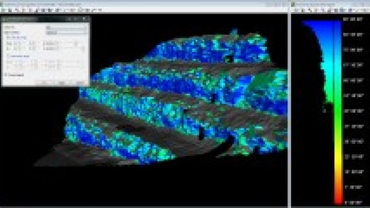
Stereonet plots allow users to plot slope and slope direction (dip and strike) onto a two-dimensional graph, helping to identify discontinuity sets and analyse the stability of rock slopes. Contours can be added for pinpointing data of interest. Rose diagrams reveal the frequency of data versus the direction of the data for identifying directional trends. Colouring surfaces by the dip or strike values of the individual facets helps to highlight discontinuities and planar areas, making it easy to see fractures.
Overlapping surfaces that have been scanned at different times can be compared to reveal extent and rate of movement, for example to identify a slow moving failure in an open pit mine. Surfaces can be coloured based on changes from a previous surface and data can be exported to measure distances from previous and base surface measurements.
I-Site Studio was first released in 2001, several years before Maptek began manufacturing 3D laser scanners. Since the mining technology leader added scanning hardware to its arsenal, the benefits for both sides of the product development coin are stacking up.
In the 10 years since its release, I-Site Studio has evolved from a powerful cruncher of massive point cloud datasets to a product containing many of the tools which surveyors now take for granted to make their job faster and easier. Open pit model update, contour and label elevations, automatic toe and crest detection, and measuring volume displacement are some of the intuitive I-Site Studio tools.
I-Site Studio 3.5 includes general enhancements in performance and usability. Filtering can now be done based on point selection, rather than the entire scan dataset. When used in conjunction with the new freehand or polygonal lasso selection tools, it reduces the time required to remove stray points caused by dust or other transient objects.
Many of I-Site Studio's existing tools have been tweaked with even more options for quickly comparing as-builts against design models to highlight variations or non-conformance.
The ability to quickly create a 3D PDF means that rotatable models can be shared with people who don't have specialised viewing software. I-Site Studio 3.5 users can also export to a Universal 3D file, meaning that the valuable information can be shared with decision makers at all levels immediately.

Value staying current with geomatics?
Stay on the map with our expertly curated newsletters.
We provide educational insights, industry updates, and inspiring stories to help you learn, grow, and reach your full potential in your field. Don't miss out - subscribe today and ensure you're always informed, educated, and inspired.
Choose your newsletter(s)


