
Maptek Releases New High-accuracy Survey-grade Solutions
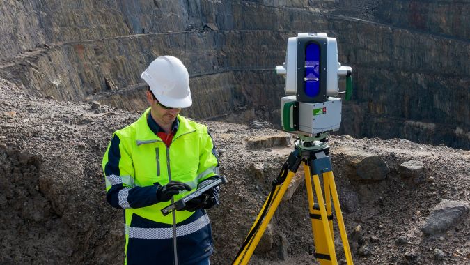
A new dual-window scanner that halves data capture time headlines the latest Maptek mine measurement improvements. The new Maptek XR3-D mkII laser scanner with dual-window arrangement is designed to cut scan acquisition time in half. Whereas conventional terrestrial laser scanners capture data from one window, spinning to achieve a 360° field of view, the XR3-D captures data from both sides simultaneously, with the scanner head only needing to spin 180°.
“Survey crews can incidentally scan surrounding terrain in both directions while they’re on their way to capture highwall and stockpile data”, said Jason Richards, global product strategy manager for Maptek. “There's no need to return to the pit later, as the haul roads, gradients and infrastructure have already been acquired seamlessly.”
According to Maptek, their July 2021 hardware release is the confluence of research into innovative sensing technologies and customer feedback, enhancing user experience through improved range, speed, image clarity and quality. Hardware models in the new R3 mkII series include the extra long-range XR3 (standard and cold climate configurations), the SR3 for short-range underground applications and the new XR3-D.
Turning geospatial data into knowledge
In another move to streamline survey practice, Maptek released its in-field scanner controller – FieldHHC – as a product in its own right. “From day 1, Maptek has built standard survey workflows into our laser scanners to deliver the most productive in-field survey experience”, said Richards. “FieldHHC improves on this, with an intuitive GUI and impressive new features ensuring that data is turned into knowledge in the fastest way.”
Dynamic 3D views of scans in progress optimize time spent on data capture in active mining environments and minimize the need to wait for in-office processing.
The on-tablet in-field assistant provides thumbnail views and detailed information on every scan, alongside instant 3D visualization, colouring and measurement tools. Full geolocation support with bluetooth connection to GPS devices for RTK corrections makes for efficient field time. Smart lighting settings for indoor, outdoor and underground conditions improve the value-in-use.
A new design conformance tool on the controller helps surveyors instantly recognize whether pit walls are conforming to design. Issues can be resolved while in the field, and dynamic reporting and cross-section output means everyone stays up to date.
Improving the automation of survey tasks
Maptek sensing systems are renowned for safety and ease of use for daily survey, with software tools providing integrated decision support. Software updates that improve and support the automation of survey tasks round out the mid-year mine measurement release. Maptek PointStudio includes enhancements to inter-ramp conformance reporting, a new Rock Quality Designation feature, additional Python integration and further display options.
Maptek Sentry, now on the Maptek Workbench with a ribbon menu, delivers enhanced interoperability for monitoring, analysing and reporting on surface movements.
Maptek has been providing mining dedicated laser scanners since 2004. The robust vehicle mount and the subsequent Maptek Drive continuous mobile mapping solution added versatility to site practice, building on a foundation of reliable, survey-grade acquisition sensors. Technology has advanced exponentially since then, as has its uptake in industry. Maptek understands that accurate data remains the lifeblood for miners.
“This release targets an important goal of reducing the time between collecting data and deriving value from it”, said Richards. To avoid ‘drowning in data’ solutions need to embrace automation. “This is key to ensuring accurate spatial data drives resource, recovery and conformance modelling and the results quickly flow through to guide planning and production teams”, Richards continued. “In-built, customisable workflows ensure users can interact dynamically with the field-captured data without becoming overwhelmed with volume and detail.”
“We remain committed to the terrestrial laser scanning approach because our customers tell us how important it is and how much they need it in their technology mix,” Richards concluded.

Value staying current with geomatics?
Stay on the map with our expertly curated newsletters.
We provide educational insights, industry updates, and inspiring stories to help you learn, grow, and reach your full potential in your field. Don't miss out - subscribe today and ensure you're always informed, educated, and inspired.
Choose your newsletter(s)


