MicroSurvey CAD 2017 Brings New Possibilities
MicroSurvey Software has released MicroSurvey CAD 2017. This updated solution for land surveying and civil engineering professionals worldwide contains several powerful new and enhanced capabilities, streamlined workflows and important bug fixes.
MicroSurvey CAD provides users with an intuitive interface on a complete survey drafting toolkit, including COGO, DTM, traversing, adjustments, volumes, contouring and more. MicroSurvey CAD is perpetually licensed and is powered by IntelliCAD which is compatible with AutoCAD drawing files. With five available feature levels – Basic, Standard, Premium, Ultimate and Studio – MicroSurvey CAD gives users the choice between several tiers of features to ensure they are getting precisely the tool they need.
Notable improvements
Notable improvements in MicroSurvey CAD 2017 include Draw Smart Polylines which automatically update when the points they connect are edited or deleted, and can be created or labelled with the same standard methods as Smart Lines and Arcs. In another addition, Draw Smart Point Blocks combine the point node and text labels into one object. Labels can be repositioned with automatic leaders connecting from the labels back to the point node.
It is now also possible to attach Bing Maps aerial, road or hybrid imagery as a raster image within your drawing file, and to use Dropbox, Microsoft OneDrive, Google Drive and other cloud storage and synchronisation services. This enables you to open and save your drawings directly in your favourite third-party service provider’s folder.
Point cloud data
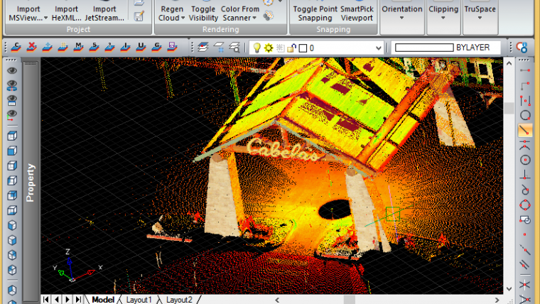
MicroSurvey CAD 2017 also includes the use of gons/gradians, decimal degrees or degrees-minutes-seconds for input and output of all angles and directions throughout the programme. A further possibility is to produce 2D or 3D animations and flythroughs with point cloud data (MicroSurvey CAD Studio only).
Customers with existing maintenance contracts can use MicroSurvey CAD 2017 immediately after updating their licence key. Customers with expired maintenance contracts or older versions can purchase an upgrade to start using the latest features.
For more information see www.microsurvey.com.

Value staying current with geomatics?
Stay on the map with our expertly curated newsletters.
We provide educational insights, industry updates, and inspiring stories to help you learn, grow, and reach your full potential in your field. Don't miss out - subscribe today and ensure you're always informed, educated, and inspired.
Choose your newsletter(s)


