
Mobile Lidar Contributes to Digital Transition of Norwegian Forestry Sector
GeoSLAM's Lidar technology is being used to map forests as part of the Centre for Research-based Innovation (SFI) SmartForest in Ås, Norway. SFI SmartForest aspires to put the Norwegian forestry sector at the forefront of technological advances and Industry 4.0.
Industry 4.0 describes advancements in digital technologies and manufacturing that are driving trends toward an interoperable future, characterized by a high degree of collaboration, a free flow of information and real-time communication. Although Industry 4.0 is still in its infancy, early adopters of smart factories - or, in this case, smart forests - can already see the benefits of interconnectivity.
Led by The Norwegian Institute of Bioeconomy Research (NIBIO), the SFI SmartForest aims to bring Industry 4.0 to forestry over an eight-year period. The primary goal is to improve the efficiency of the Norwegian forestry sector by enabling a digital transformation, using innovative technologies. The objectives are to increase productivity, reduce environmental impacts and review other significant climate benefits.
Focusing on silviculture, forest operations, wood supply and the overall digital information flow, SmartForest is investing in sensible enabling technologies - such as handheld Lidar sensors - to help achieve its goals. One such Lidar solution is the GeoSLAM ZEB Horizon laser scanner.
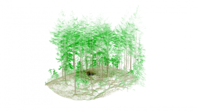
Combining Handheld and UAV Laser Scanning
Walking and scanning with the ZEB Horizon captures data from beneath the forest’s canopy. Projecting 300,000 laser points per second with a range of up to 100 metres, the scanner produces dense 3D models of large areas in a short period of time. The accurate point cloud data includes the forest floor, debris, tree trunks and thick vegetation. When needed, UAVs capture the heavy vegetation of the forest canopy, merging both datasets.
The team, headed by centre manager Rasmus Astrup, regularly captures point cloud data in 250-square-metre plots of land, with a further ambition to scan larger areas in the future. Frequent data acquisition is a key part of SmartForest's plans, and GeoSLAM's handheld Lidar scanners alongside UAV data capture help to achieve this. The ZEB Horizon is developed to make data acquisition a simple, repeatable task for Rasmus and his team and the high-accuracy data provides a foundation for deep learning models.
Automatic segmentation of the tree trunks allows for easier counts, and provides precise forest inventory down to the individual tree. The segmentation will lead to the extraction of features for specific trees such as wood quality, biomass and other ecologically relevant variables for monitoring forest health.
Commenting on the scanner, Stefano Puliti, research scientist at NIBIO, said: “The speed that the ZEB Horizon collects data makes the whole workflow very simple and attractive to companies because it will save them time. It is an efficient way to collect ground truth, which gives us an edge. Eventually, we want to use it for large-scale mapping applications.”
The project is still in the early stages, but SmartForest is already looking at other potential uses for GeoSLAM's ZEB Horizon scanner, acknowledging the versatility of the handheld Lidar solution.

Value staying current with geomatics?
Stay on the map with our expertly curated newsletters.
We provide educational insights, industry updates, and inspiring stories to help you learn, grow, and reach your full potential in your field. Don't miss out - subscribe today and ensure you're always informed, educated, and inspired.
Choose your newsletter(s)


