Mobile Spatial Imaging System
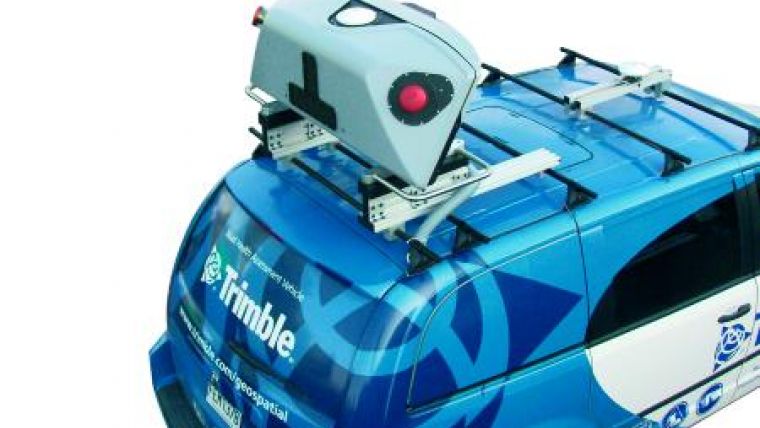
The Trimble MX8 Mobile Spatial Imaging System is an advanced mobile data capture system that combines imaging and laser scanning capabilities to measure objects in 3D to produce 3D, 4D and 5D data sets for spatial imaging projects. The Trimble MX8 Mobile Spatial Imaging System expands the scope of services that surveyors, engineers, mapping and geospatial professionals can offer. The system is ideal for as-built modelling, inventory, inspection, encroachment analysis, and asset management for roadways, bridges, railways, utilities, and other infrastructure.
With recent advances in the geospatial information industry, more opportunities and applications for spatial imaging data are being identified for industries such as transport and civil engineering, utilities and communications, natural resources management, and government. Many of these applications use airborne information, but would also benefit from ground-based positioning and imaging. While satellite and aerial imaging provide exceptional overhead views and long-range details, the only way to capture comprehensive eye-level views is from the ground. A ground-based sensor such as the Trimble MX8 is an ideal solution that delivers centimetre positioning accuracy, 3D measurements and video imaging-at highway speeds.
Integrating imaging and laser scanning with advanced Global Navigation Satellite System (GNSS) plus Inertial positioning, the Trimble MX8 collects 3D data fast and accurately. Featuring a pod-type design, it is easily redeployed and installed on a variety of vehicles as project demands change. A scalable system configuration and sensor upgrade options allow owners to address their evolving needs.
Operating at highway speeds, the Trimble MX8 allows users to capture more frequent updates of 3D datasets for roadway and right-of-way infrastructure. Combined with Trimble Trident Analyst for Spatial Imaging software, automated extraction of road signs, road geometry, break lines and lane markings reduces manual labour and provides answers earlier in the project. Change detection between current and past datasets allows monitoring of project progress throughout the plan, design, build and maintain phases.
Mobile imaging and laser scanning systems create immense datasets that can quickly overwhelm manual workflows. Advanced software automation allows users to better leverage their existing workforce and pursue new business opportunities while realizing reduced total cost of ownership. Automated feature extraction allows service companies and organizations to create more value for their customers and end users by delivering answers instead of data.
The Trimble MX8 Mobile Spatial Imaging System is expected to be available in the third quarter of 2010 through Trimble's GeoSpatial sales channels.

Value staying current with geomatics?
Stay on the map with our expertly curated newsletters.
We provide educational insights, industry updates, and inspiring stories to help you learn, grow, and reach your full potential in your field. Don't miss out - subscribe today and ensure you're always informed, educated, and inspired.
Choose your newsletter(s)


