Monitoring Flooding and Assessing Damage in the Czech Republic
Heavy rainfall in late May and early June 2013 caused the Rivers Elbe, Vltava and Kamenice to burst their banks in the Czech Republic. Among other areas, the Troja area of Prague and the villages of Hrensko and Nové Kopisty were severely flooded. Here, the author describes the experiences gained by the Czech company Geodis while using UAS technology to monitor and assess the impact of the floods for the first time. Having proved that it can provide geodata quickly, cheaply and efficiently, UAS is now attracting significant interest from authorities.
Geodis is the producer of the countrywide orthoimagery, resolution 12.5cm, and the Digital Elevation Model (DEM), with grid spacing of 10m, of the entire Czech Republic. The revision cycle of both products is three years. The company has monitored large-scale floods in the Czech Republic since 1997 – mainly by traditional airborne photogrammetry, up until 2013. Products derived from overlapping aerial imagery such as georeferenced orthomosaics, DEMs, flood levels and maps of waterways support water boards, municipalities and other authorities in taking flood prevention measures and in decision-making when flooding has occurred.
UAS Ownership
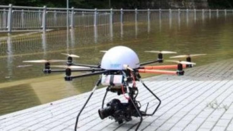
Since 2012, Geodis is the owner of two types of UAS: the quadrocopter MD4-1000 from the company microdrones and an octocopter developed in-house. Both systems are equipped with GNSS, gyroscopes, accelerometers and compasses. They are used in a variety of projects which are often carried out in co-operation with research institutions and universities. The MD4-1000, equipped with a Canon EOS 5D Mark III, has a maximum speed of 12m/s, can stay airborne for 25 minutes, weighs 6.2kg with sensor on board and can carry a load of up to 1.5kg. The 22MP Canon camera contains a high-quality chip and is able to capture HD video. The octocopter developed in-house has a maximum speed of 15m/s, can stay airborne for 15 minutes with the above-mentioned Canon EOS 5D Mark III on board, weighs 9.5kg and can carry a load of up to 6kg. The ability to carry a relatively large and heavy payload of 6kg is advantageous for capturing inaccessible areas with a pallet of sensors, including thermal infrared sensors and multispectral and professional cameras. Other features include retractable legs and a remote-controlled camera which is wirelessly connected to a monitor, thus allowing the operator to follow the flight in real time. The rotation of the camera around three axes can be steered by the operator and allows dynamic shots which can be directly transmitted to authorities for decision-making purposes.

Value staying current with geomatics?
Stay on the map with our expertly curated newsletters.
We provide educational insights, industry updates, and inspiring stories to help you learn, grow, and reach your full potential in your field. Don't miss out - subscribe today and ensure you're always informed, educated, and inspired.
Choose your newsletter(s)


