Myanmar's Cyclone-Damaged Rice Production Regions Monitored with GIS
Subsequent to Cyclone Nargis, a category 3 tropical storm that struck the low-lying and heavily populated coastline of Myanmar on 2nd May 2008, the Foreign Agriculture Service (FAS) of the U.S. Department of Agriculture (USDA) began producing a series of GIS-based maps of the damaged agricultural areas to accompany its commodity intelligence reports. Published on the FAS Web site, these maps are created using geospatial data and the technology found in ESRI's ArcGIS Desktop software.
The mission of FAS is to improve foreign market access to U.S. agricultural products, build new markets, improve the competitive position of U.S. agriculture in the global marketplace, and provide food aid and technical assistance to foreign countries. FAS achieves a part of this mission by analysing global crop production capacity with remote-sensing and GIS tools and by issuing commodity intelligence reports highlighting current international crop conditions.
GIS-based maps, available in PDF format, provide a visualisation of the analysis performed and often serve as each report's basis. The commodity intelligence reports issued for Myanmar focus on its major rice-producing areas, which have suffered saltwater flooding and heavy rainfall as a result of the cyclone.
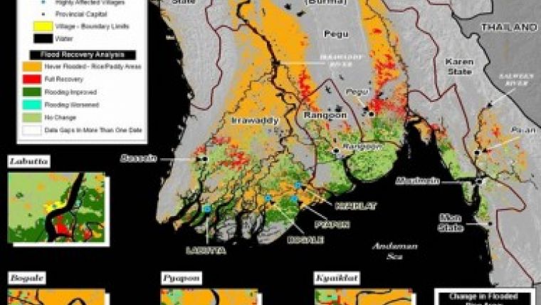
The project included satellite imagery obtained from the National Aeronautics and Space Administration's (NASA) moderate-resolution imaging spectroradiometer (MODIS) satellite to delineate the postcyclone flooding region. This imagery was combined with rice land-cover classification data from the Landsat satellite program. FAS used ArcGIS to perform spatial analysis and create maps of the damaged rice production regions of Myanmar. These maps revealed the cyclone's effect on cropland and livestock, the severity of flooding, and the rate of cropland recovery. The United Nations and nongovernmental organisations (NGO) are using the maps to evaluate the scope of the cyclone's impact. The information is also been of great interest to the international agriculture industry for determining market impacts.
A commodity intelligence report and maps issued on 10th June 2008, demonstrate that approximately 80 percent of the original inundated rice production area is still affected by some degree of flooding, though conditions in the core damage zone had improved considerably, with only 418,000 hectares, or 46 percent of the original area, still showing flood effects. FAS will continue to produce reports and maps and perform analysis of Myanmar's rice production regions as new data becomes available.
As a complete GIS, ArcGIS allows organizations such as USDA to author data, maps,
globes, and models on the desktop; serve them to a GIS server; and use them through Web, desktop, and mobile clients. The ArcGIS family of products includes desktop, server, mobile, and online GIS as well as ESRI data.
Caption: Burma: Post-Flood Rice Impact Analysis - May 30, 2008

Value staying current with geomatics?
Stay on the map with our expertly curated newsletters.
We provide educational insights, industry updates, and inspiring stories to help you learn, grow, and reach your full potential in your field. Don't miss out - subscribe today and ensure you're always informed, educated, and inspired.
Choose your newsletter(s)


