
NavVis and AVEVA Join Forces to Energize the Digital Twin
NavVis is partnering up with AVEVA to provide users with the technology to access reliable as-built 3D point cloud data and panoramic images. NavVis is known for its advanced reality capture, digital factory, and digital plant solutions. AVEVA is a global leader in industrial software.
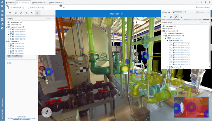
A digital twin is only as good as the data that composes it. Without solid data, a digital twin can fall short of the expectations. AVEVA Point Cloud Manager is developed to manage massive amounts of 3D point cloud data to create an accessible, detailed and secure digital twin. It can process huge, meticulous datasets with engineering-grade accuracy, ensuring that physical and digital project representations perfectly align. This allows users to make trustworthy, informed decisions, reduce project rework, and improve safety on critical assets.
“Together, AVEVA Point Cloud Manager and NavVis wearable scanning technology represent a very rapid way of creating and updating digital twins,” said Andy Davidson, product manager for AVEVA Point Cloud Manager.

Digital Twins of Complex Industrial Environments
Once the NavVis VLX has captured data, that data is then processed to deliver high-quality data in e57 formats (a vendor-neutral file format for point cloud storage) that contain both 3D point cloud data and panoramic images, without creating additional work for the user. This information is imported into AVEVA Point Cloud Manager, where users can take measurements of the data, link with CAD systems, and publish the dataset for integration with the wider digital twin.
“We look forward to enhancing AVEVA digital twins with our very fast and accurate NavVis VLX devices and high-quality e57 data, processed and prepared in NavVis IVION,” commented Ignacio Pérez Hallerbach, vice president and global head of partners & platform at NavVis.
Coupled with NavVis’s hardware capabilities, AVEVA Point Cloud Manager enables users to easily and instantly visualize and access reliable as-built laser point cloud data. Together, these technologies empower multi-discipline, geographically disparate teams to collaborate on the same data at the same time with interactive project reviews. As a result, it is possible to significantly reduce the time and cost of on-site survey and inspection requirements and to maximize office-based time and resources.

Value staying current with geomatics?
Stay on the map with our expertly curated newsletters.
We provide educational insights, industry updates, and inspiring stories to help you learn, grow, and reach your full potential in your field. Don't miss out - subscribe today and ensure you're always informed, educated, and inspired.
Choose your newsletter(s)


