New Digital Elevation Models in North Macedonia
Kartverket, the Norwegian mapping authority, is using airborne Lidar scanning in a project for the territory of North Macedonia. The resulting highly accurate digital elevation models will be distributed to end users through a Lidar portal.
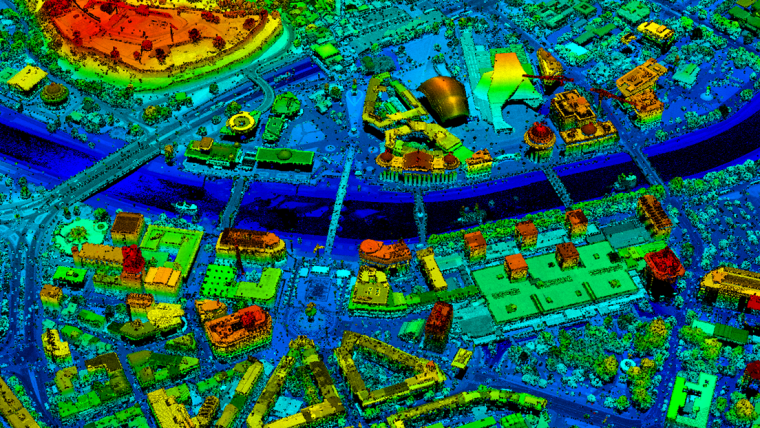
Lidar surveying acquires high-accuracy digital elevation model (DEM) data, allowing capture of the bare earth structure that satellites cannot see as well as ground cover in sufficient detail to allow vegetation categorization and change monitoring.
The high resolution and positional accuracy of Lidar means it can be used to capture and measure above-ground features over large areas, including power lines, building outlines and towers.
Collecting essential geospatial data
The data created will be particularly useful and valuable for a wide range of applications – not only flood risk mitigation, flood monitoring and for actions during flood situations in flood-exposed areas, but also for reducing the cost of infrastructure projects, enhancing environmental protection and monitoring and spatial planning.
“This Lidar project is among the projects that may have the biggest impact on today’s North Macedonian geospatial community and society as a whole,” says Sasho Dimeski, project manager at Agency for Real Estate Cadastre (AREC). The project marks the first time that Lidar mapping technology has been used in North Macedonia to collect such high-quality geospatial data that is essential in so many areas of society.
Sharing data and capacity building
One of the key objectives of the project was to develop a new technical solution for the distribution of digital terrain data. A Lidar portal has been set up in order to provide public access to Lidar data and derived products to all interested users. Lidar-scanned data has also been shared with the United Nations Development Programme’s country office, as part of its strategic plan for implementation of the Sustainable Development Goals through the ongoing project called ‘Improving Resilience to Floods in the Polog Region’. It will not be possible to achieve these goals without sufficient, reliable, up-to-date, high-resolution digital maps. Thus, it is natural to share responsibilities and strengthen joint efforts to fight the threat of climate change.
As a part of every developing project, Kartverket promotes the sharing of experiences and the transfer of knowledge to its project partners. In this project, it has successfully enhanced AREC’s capacity for maintaining and distributing digital terrain data.


Value staying current with geomatics?
Stay on the map with our expertly curated newsletters.
We provide educational insights, industry updates, and inspiring stories to help you learn, grow, and reach your full potential in your field. Don't miss out - subscribe today and ensure you're always informed, educated, and inspired.
Choose your newsletter(s)


