New Elevation Map Reveals Yellowstone's Complex Geological History
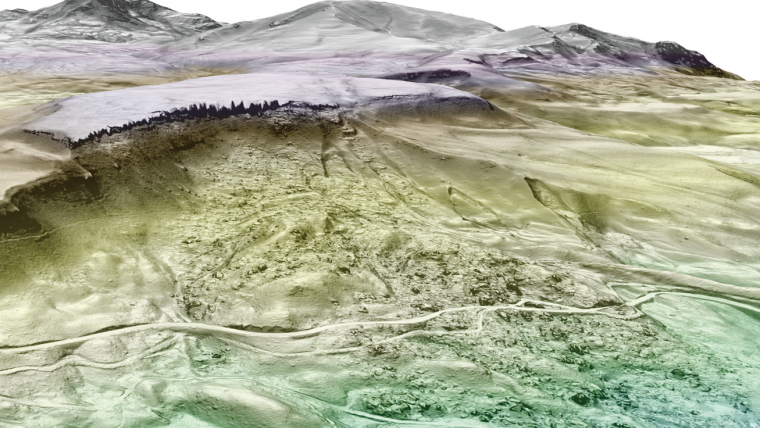
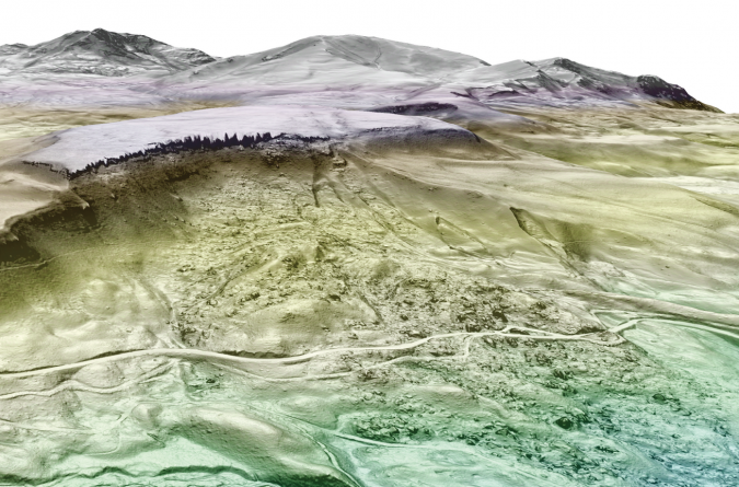
High-resolution topographic data reveals new faults, landslides, hydrothermal systems and volcanic features never documented before. Able to see through vegetation, Lidar maps the bare earth, unveiling the impact of past events and current processes that shape Yellowstone National Park in the USA.
The topographic texture of the Earth’s surface tells a story. From afar, we see ridges and valleys, shaped over thousands of years, sculpted by rivers and glaciers. Zooming into an individual hillside or a stretch of river bottom, subtle bumps and breaks in the land’s surface reveal the imprint of past events, such as floods or landslides. The scale at which geologists observe landscapes influences the stories they tell about them.
Previous generations of scientists interpreted Yellowstone’s landscape using aerial photos or through fieldwork; both techniques are complicated by the presence of dense vegetation. An unprecedented, high-resolution Lidar topographic dataset released in February 2022 changes all that. When a Lidar system is mounted on an aircraft, it allows for high-resolution mapping of topography and can even effectively “see” through vegetation. In the same way that the invention of the microscope enabled biologists to visualize the inner workings of cells, Lidar offers geoscientists access to the subtle and often obscured textures of the earth’s surface.
290 Billion Individual Laser Measurements
In the autumn of 2020, a small plane flew 436 overlapping swaths of Lidar data over Yellowstone National Park, systematically traversing the area like a lawnmower. Pulsing out the belly of the plane, a downturned laser swept side-to-side, precisely measuring the elevation of the bare earth below. After 16 months of processing, the data was released to the public. Over 290 billion individual measurements resolve the park’s topography at a resolution of slightly less than one measurement every square metre and capable of detecting elevation differences of just a few centimetres. This just about enables to resolve individual bison grazing in Lamar Valley or measure the height of Old Faithful’s sinter cone.
For geologists and geomorphologists who study the shape of landscapes, Lidar data not only reveals the presence of unmapped features of the landscape, but also allows measurement of the size and character of these features.
Read the full story at the Yellowstone Volcano Observatory website.

Value staying current with geomatics?
Stay on the map with our expertly curated newsletters.
We provide educational insights, industry updates, and inspiring stories to help you learn, grow, and reach your full potential in your field. Don't miss out - subscribe today and ensure you're always informed, educated, and inspired.
Choose your newsletter(s)


