New Map Reveals Antarctica without Ice
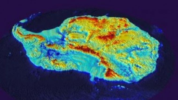
Scientists at the British Antarctic Survey have been working with a host of international collaborators to present the most detailed map yet of Antarctica’s landmass. Bedmap2 reveals a landscape of mountain ranges and plains cut by gorges and valleys much deeper than previously seen. In addition, the map allows scientists to analyse the bed below the Antarctic ice sheet in much greater detail.
Several features of the bed have been revealed for the first time including a new deepest point. The bed under the Byrd Glacier in Victoria Land is 2,870 metres below sea level making it the lowest point on any of the Earth’s continental plates.
The map was compiled using datasets collected from radio echo sounding measurements, seismic techniques, satellite readings and cartographic data.
A number of key statistics emerge:
- The volume of ice in Antarctica is 4.6% greater than previously thought
- The mean bed depth of Antarctica, at 95 metres, is 60 m lower than estimated
- The volume of ice that is grounded with a bed below sea level is 23% greater than originally thought meaning there is a larger volume of ice that is susceptible to rapid melting. The ice that rests just below sea level is vulnerable to warming from ocean currents
- The total potential contribution to global sea level rise from Antarctica is 58 metres, similar to previous estimates but a much more accurate measurement
- The new deepest point, under Byrd Glacier, is around 400 metres deeper than the previously identified deepest point.
Peter Fretwell, British Antarctic Survey, explaines the new Bedmap shows, with unprecedented detail, the bedrock beneath the ice sheets of Antarctica. Before we had a regional overview of the topography, but this new map, with its much higher resolution, shows the landscape itself; a complex landscape of mountains, hills and rolling plains, dissected by valleys troughs and deep gorges.
Dr Hamish Pritchard, co-lead author of the study, commented that the Bedmap2 project is about more than making a map of the landscape. The data put together on the height and thickness of the ice and the shape of the landscape below are fundamental to modelling the behaviour of the ice sheet in the future. This matters because in some places, ice along the edges of Antarctica is being lost rapidly to the sea, driving up sea level. Knowing how much the sea will rise is of global importance, and these maps are a step towards that goal.
View the research paper here.
Image courtesy: British Antarctic Survey.

Value staying current with geomatics?
Stay on the map with our expertly curated newsletters.
We provide educational insights, industry updates, and inspiring stories to help you learn, grow, and reach your full potential in your field. Don't miss out - subscribe today and ensure you're always informed, educated, and inspired.
Choose your newsletter(s)


