New Miniature INS Module with External GNSS Receiver
Xsens has expanded its MTi product portfolio by introducing the MTi-7, a miniature inertial navigation system (INS) module which uses input from an external global navigation satellite system (GNSS) receiver to provide an accurate, real-time position, velocity and orientation data stream.
The MTi-7 module, which has a compact 12 mm x 12 mm footprint and weighs less than 1 gram, consumes under 100 mW, making it ideal for use in space- and power-constrained devices such as Unmanned Aerial Vehicles (UAVs), as well as autonomous or remote-controlled mapping and imaging equipment.
Autonomous ground vehicles
Operating at output data rates up to 800 Hz, the MTi-7 achieves very low latency of 2 ms, allowing for real-time operation of dynamic functions such as flight control and camera stabilisation. The module also offers a position and velocity output, suitable for the navigation of autonomous ground vehicles in sectors such as smart farming and robotics.
The high performance of the MTi-7 is due to the advanced sensor fusion algorithms developed by Xsens to synchronise the inputs from the module’s on-board accelerometer, gyroscope and magnetometer with the signals from an external GNSS receiver or barometer. The raw sensor signals are combined and processed at high speed in the MTi-7 module to produce a real-time data stream showing the device’s horizontal and vertical position, velocity, roll, pitch and yaw. This user-friendly data stream may be supplied to a host processor via a standard I2C, SPI or UART interface.
Demand for accurate control
Based on the design of the successful MTi 1-series, the MTi-7 offers a straightforward upgrade path for current MTi-1 users on the same form factor. It is also able to provide heading, positioning and orientation accuracy more commonly found in much larger, heavier and higher-power devices.
Hein Beute, director product marketing at Xsens, said they are seeing exploding demand for accurate control of autonomous or computer-guided equipment such as drones and smart farming ground vehicles. With its tiny footprint, light weight and low power consumption, the MTi-7 provides the industry’s best solution for any such application that is limited in terms of space or power but that needs a high degree of accuracy and precision in position and orientation data, he added.
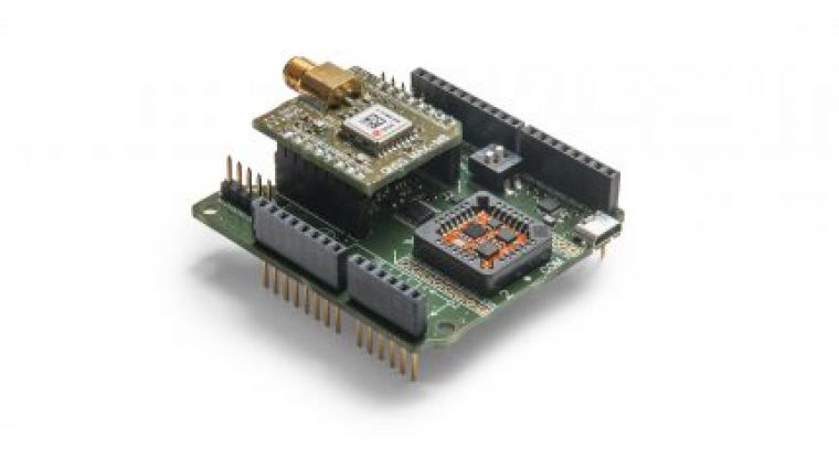
The MTi-7 module is supported by an Arduino-compatible development kit (the MTi-7-DK), which provides access to the module’s I2C, SPI and UART interfaces via micro-USB connections. Developers can configure the operation of the MTi-7 via the freely available Xsens MT Software Suite. The MT Software Suite includes a GUI for PCs operating on the Linux or Windows platforms, as well as a full Software Development Kit including example source codes and complete documentation.
Users of the MTi-7 also benefit from the Xsens MTi 1-series ‘No End of Life’ policy, which guarantees availability of the MTi-7 or a pin- and function-compatible alternative for the duration of the customer’s product lifetime.

Value staying current with geomatics?
Stay on the map with our expertly curated newsletters.
We provide educational insights, industry updates, and inspiring stories to help you learn, grow, and reach your full potential in your field. Don't miss out - subscribe today and ensure you're always informed, educated, and inspired.
Choose your newsletter(s)


