New OGC API for Publishing Vector Geospatial Data in any Coordinate Reference System
Collection, processing and dissemination are some of the key aspects of the data lifecycle in geomatics. A major challenge for data managers is always how to maintain an appropriate level of quality as data goes through this lifecycle. The popularity of the World Geodetic System 1984 (WGS 84) datum has previously led to many data products being published with coordinates referenced to WGS 84. What then for those data users that depend on other Coordinate Reference Systems (CRS) for their work?
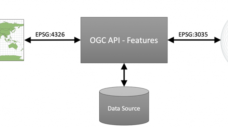
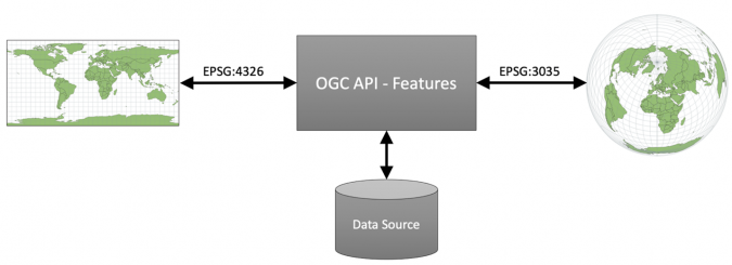
Acknowledging the increasing need for an Application Programming Interface (API) that allows for the publication of vector geospatial in any CRS, the Open Geospatial Consortium (OGC) has recently announced the approval of an extension to OGC API - Features that addresses this need. OGC API - Features provides the fundamental API building blocks to create, modify, and query ‘features’ on the Web (features are simply the digital representations of objects of interest in the real world). OGC API - Features comprises multiple parts, with each part being a separate standard. Whereas Part 1 of OGC API - Features only specifies access to vector data in WGS 84, the new Part 2 of the standard extends Part 1’s capabilities with the ability to access data that is in any CRS that is identifiable by a Uniform Resource Identifier (URI). Figure 1 illustrates this ability by showing the same source data transformed to different CRS, namely WGS 84 (labelled EPSG:4326) and ETRS89-extended / LAEA Europe (labelled EPSG:3035).
What’s in the new OGC API – Features extension?
Specifically, the OGC API - Features - Part 2 standard specifies:
- How, for each offered feature collection, a server advertises the list of supported CRS identifiers;
- How the coordinates of geometry-valued feature properties can be accessed in one of the supported CRS;
- How features can be accessed from the server using a bounding box specified in one of the supported CRS; and
- How a server can declare the CRS used to present feature resources, and optionally the coordinate axis order used.
So where does one obtain URIs that uniquely identify CRSs?
The definitions of CRS are accessible through URIs to ensure that they are unique. Each CRS supported by a server is required to be referenceable through a URI. To facilitate this, the OGC provides a register of CRS definitions accessible through the OGC Definitions Server - a Web accessible source of information about things ("Concepts") the OGC defines or that communities ask the OGC to host on their behalf. The entrypoint to the CRS register on the Definitions Server is http://www.opengis.net/def/crs/.
So what does it mean for geospatial professionals?
It means, for example, that if you are a surveyor collecting data that is referenced to the British National Grid (BNG), that data can remain in BNG coordinates all the way from storage, through to transmission, and onwards to visualization on a Geographic Information System (GIS). This greatly simplifies the processing and reduces the risk of errors being introduced during coordinate conversion. Similarly, for surveyors collecting and disseminating data in national or regional CRS such as the European Terrestrial Reference System 1989 (ETRS 89) and the North American Datum of 1983 (NAD 83). They too can now publish data based on ETRS 89 or NAD 83 without needing to convert the data to a different CRS.
OGC API - Features is one of a number of standards being developed in the OGC API family of standards. OGC APIs usher in a new age for discovering and accessing geospatial data on the Web, greatly simplifying the way users share and access data. The OGC API family of standards defines modular API building blocks to spatially enable Web APIs in a consistent way. The new OGC APIs make use of the OpenAPI Specification (OAS) – a broadly adopted industry standard for describing modern APIs. The OAS defines a language-agnostic interface to Web APIs that allows humans and computers to discover the capabilities of a service without needing to access the source code, documentation, or network traffic of the service and thus be able to interact with the service.
What is the impact of OGC API – Features so far?
With just over a year since the release of Part 1 of OGC API - Features, the standard has already begun to have an impact globally. For example, the International Organization for Standardization (ISO) has approved Part 1 under the name ISO 19168-1:2020 Geographic information — Geospatial API for features — Part 1: Core. Further, the community of more than 30 states that are implementing the INSPIRE Directive has endorsed the API as a Good Practice for an INSPIRE download service. The INSPIRE Directive aims to create a European Union (EU) spatial data infrastructure for the purposes of EU environmental policies and policies or activities which may have an impact on the environment. Part 2 of the standard is expected to have even greater utility in geomatics due to its support for a variety of CRS. As with any OGC standard, this OGC standard is free to download and implement. Interested parties can view and download the standard from the OGC API - Features Page at https://ogcapi.ogc.org

Value staying current with geomatics?
Stay on the map with our expertly curated newsletters.
We provide educational insights, industry updates, and inspiring stories to help you learn, grow, and reach your full potential in your field. Don't miss out - subscribe today and ensure you're always informed, educated, and inspired.
Choose your newsletter(s)


