New Partnership Combines Aerial and Mobile Mapped Data
To fuel a growing demand for virtual city applications in the UK, aerial mapping company Bluesky International is working with the Dutch mobile mapping specialist Cyclomedia to bring together imagery and height data, captured both from the air and at street level.
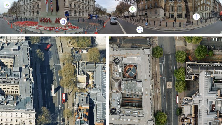
Cyclomedia currently captures and processes around 375,000 miles of 360-degree panoramic street-level images and Lidar data worldwide – the equivalent to 30 million recordings a year. Enhanced by powerful artificial intelligence-powered analytics, this data provides large-scale systematic visualizations of physical environments, using specialized technology, from moving vehicles.
Hybrid airborne mapping
Using its hybrid airborne sensors, Bluesky has already flown many UK cities. Simultaneously capturing ultra-high resolution oblique and vertical aerial photography together with highly accurate Lidar data, these Bluesky MetroVista products can provide large area aerial context for Cyclomedia’s street level detail.
“By bringing together two best-of-breed solutions in a single platform, we are ever closer to fulfilling the growing demand for true virtual cities available from the desktop,” commented Rachel Tidmarsh, managing director of Leicestershire-based Bluesky International. “Cyclomedia has been a pioneer in the field of mobile mapping for 40 years and has completed projects around the world, so was a perfect fit for Bluesky.”
“Working with Bluesky we can ensure that users are getting the best of both worlds,” added Duncan Guthrie, vice president Europe at Cyclomedia. “We now have city-wide coverages achieved through aerial acquisition complementing street-level fidelity from our vehicle mounted sensors. Accessible through a single platform this will enhance a host of customer applications that require up-to-date, accurate, photo-realistic 3D city models.”
Petabytes of imagery
Bluesky provides a range of aerial imaging and remote sensing collection and processing services and is the only organization to have current, high-resolution, full coverage of the Republic of Ireland, England, Scotland and Wales, which it maintains on a rolling, three-year update cycle. Bluesky has also upgraded its national flying programme to a minimum 12.5cm resolution with urban areas now being captured at 5cm resolution simultaneously with Lidar and oblique imagery.
Cyclomedia develops, builds and operates the world’s most advanced mobile mapping systems. A combination of sensors ranging from cameras and Lidar scanners to state-of-the-art positioning systems map dense urban areas in Western Europe and North America. The petabytes of data that are collected every year are used by professional users, ranging from city governments to large corporates working in utilities, infrastructure and insurance.

Value staying current with geomatics?
Stay on the map with our expertly curated newsletters.
We provide educational insights, industry updates, and inspiring stories to help you learn, grow, and reach your full potential in your field. Don't miss out - subscribe today and ensure you're always informed, educated, and inspired.
Choose your newsletter(s)


