NV5 Introduces Multifunctional Rugged Robot for Electric Substation Monitoring
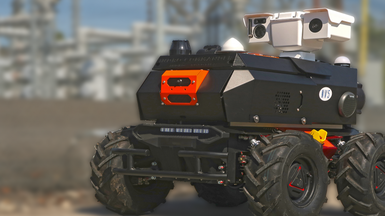
NV5 Geospatial has announced the debut of the ARIS II Rover, its upgraded robotic electric substation monitoring system. After five years of in-field implementation and testing, the rover meets the industry’s most exacting standards for ruggedness and reliability. It is able to function in harsh environmental conditions and on the various terrains that are commonly found at distribution and transmission substations. NV5 Geospatial is one of North America’s most comprehensive geospatial science data firms.
The remote-controlled wheeled rover has a modular design and is custom-fitted with advanced thermal sensors, imaging and audio/video technology. It allows utility companies to protect assets and limit liability while speeding up reaction times.
Remotely Delivered Geospatial Data
“Geographic and personnel limitations, combined with aging infrastructure, present significant challenges for utility companies when it comes to maintaining their substations,” said Ian Birdie, vice president of innovation at NV5 Geospatial. “With our extensive experience in these substation environments, NV5 Geospatial has customized the ARIS II Rover for the unique needs of utilities. We built our next-generation robot on a rugged platform that can exist remotely and deliver the information and insights utilities need to maintain their networks proactively. On-time information allows quick response to equipment anomalies, weather events and intrusions before they have an impact.”
The ARIS II Rover supports a variety of applications, including event check-ups, situational awareness, health monitoring, work audits, inventory management, emergency response and security. It incorporates a multitude of advancements such as industry-leading military standards (MIL-STD) and ingress protection ratings, resulting in a weatherproof design that can withstand harsh environments, and 36-degree climbing ability enabling it to cope with challenging terrain. In addition, the pre-configured payload of sensors and equipment supports thermal imaging, video and two-way audio communication capabilities, while the GPS with real-time kinematics (RTK) facilitates accurate mapping as the rover drives around substation.
Sensors and Cameras
The modular design offers flexibility in sensor and camera positioning and simplified maintenance on or off site, with the ability to carry up to 50kg of equipment. Thermal imaging sensors capture temperature deltas against assets in equipment evaluations. Onboard cameras can visually detect corrosion and asset damage, and are able to read gauges from up to 15m away.
Users have access to a secure web portal that offers controls and management tools to support real-time inspection/driving, feedback and measurements from onboard sensors, and allows them to review and assess thermal conditions and high-resolution photos. As a result, the ARIS II Rover can be a valuable tool in helping utility companies to assess conditions in substations.

Value staying current with geomatics?
Stay on the map with our expertly curated newsletters.
We provide educational insights, industry updates, and inspiring stories to help you learn, grow, and reach your full potential in your field. Don't miss out - subscribe today and ensure you're always informed, educated, and inspired.
Choose your newsletter(s)


