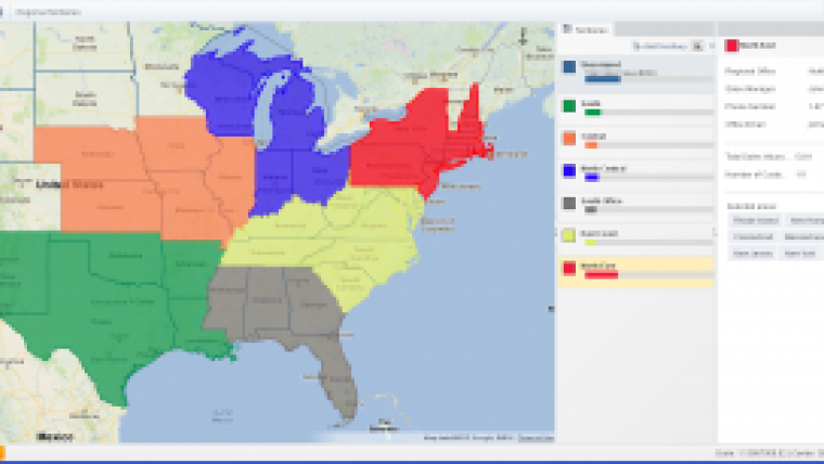
Online Mapping Software Updated to Include Territory Mapping
eSpatial, the Ireland-based online mapping software company, has released a new upgrade to its flagship product, also called eSpatial. The upgrade features several significant enhancements including territory mapping. Users can now design, refine and label their own unique territories according to country, state or post code and quickly generate territory mapping reports, highlighting the spread and breakdown of resources in a given region.
The company commented that one of the key advantages of using its online mapping software is that, once created, territory maps or reports can then be quickly and easily shared or embedded online or in documents. eSpatial believes that the addition of a territory mapping tool will help clients manage sales teams or representatives more effectively, reduce costs and highlight potential market opportunities.
As well as Territory Mapping, the latest update will allow users to edit data already uploaded to eSpatial. This avoids the need to edit content in a spreadsheet and then re-upload it. The new update can also generate two types of distance map: Within Distance and Nearest Neighbor. This allows distances between two types of datasets (e.g. shops to distribution centres) to be visualised quickly and clearly.
Announcing the update, Philip O’Doherty, CEO at eSpatial, emphasised that all the new features had come as a direct result of feedback from the company’s existing customer base. He said he was delighted with the new functionality – particularly territory mapping, which many users had requested. He added that the new developments showed eSpatial’s commitment to customer needs and its desire to continually enhance and improve its online mapping software.
The update can be accessed, free-of-charge, by existing eSpatial users when they log on. New or prospective users can also visit the company’s website and sign up for a free 7-day trial.
This is the second update to eSpatial, which was launched last September. Previously, the company had concentrated on its on-demand GIS services. However, its software product has proved popular and it is currently being used by a diverse number of clients worldwide, in both the commercial and non-profit sectors.
eSpatial describes itself as being run by “mapping enthusiasts”. The company has been delivering geographic solutions for over a decade and it says that it is committed to helping users reach their mapping goals. Philip O’Doherty said eSpatial has many more dynamic and innovative features in development – some of which he hopes to announce in the coming weeks.

Value staying current with geomatics?
Stay on the map with our expertly curated newsletters.
We provide educational insights, industry updates, and inspiring stories to help you learn, grow, and reach your full potential in your field. Don't miss out - subscribe today and ensure you're always informed, educated, and inspired.
Choose your newsletter(s)


