Optech’s Transportation Survey Solutions at TRB 94th Annual Meeting
Canada-based Optech’s laser and camera 3D sensing technology will be on display from 11-15 January 2015 in booth 760 at the 94th Annual Meeting of the Transportation Research Board (TRB) in Washington D.C, USA. In addition to mobile solutions that capture survey-grade data from roads, rails and rivers and long-range static survey solutions integrated with UAV photogrammetry, Optech will also provide information about our multisensor airborne packages for corridor applications.
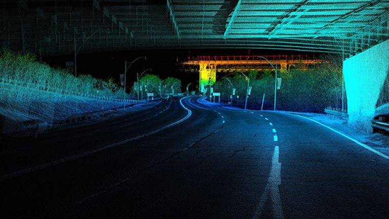
Aimed specifically at the transportation survey market, the Optech Lynx Mobile Mapper is a powerful mobile lidar/camera system that provides dense and precise 3D data even from vehicles moving at highway speeds. Transportation professionals interested in widescale mapping projects can check out the cost-efficient Lynx MG1 model, while those that need precise survey-grade data without skimping on collection efficiency will find that the industry-leading SG1 model is ideal for their tasks. The hidden jewel is the Optech Lidar Mapping Suite (LMS) software, which maximizes accuracy from both models with rigorous automation and scales up for large projects with distributed and batch processing.
Detailed surveying of assets like bridges and overpasses is easy and efficient with the ILRIS terrestrial laser scanner, which collects 3D data with cm-level accuracy even at long ranges. For applications that need a bird’s-eye view as well, Optech is pleased to deliver details on ILRIS Scan UAV, a complete hardware and software package that combines terrestrial lidar and UAV photogrammetry in Optech’s special processing software to produce full-color 3D views of the entire survey site.
For extensive areas and hard-to-access corridors, the Optech Orion and Galaxy offer rapid airborne lidar surveying with features that ensure efficient and cost-effective operations. Installable on light aircraft, these advanced airborne lidars provide real-time data for in-air quality assurance and keep your swath on-target with automatic roll compensation and an optional gyro-stabilized mount. Whether installed in a fixed-wing aircraft or in one of Optech’s specially designed helipods, these lidars can integrate with any and all of Optech’s CS-series of CIR, RGB, thermal or multispectral cameras in a system customized to fit your specific project requirements.
Image: Lynx collects accurate 3D data at speeds up to 100 km/h.

Value staying current with geomatics?
Stay on the map with our expertly curated newsletters.
We provide educational insights, industry updates, and inspiring stories to help you learn, grow, and reach your full potential in your field. Don't miss out - subscribe today and ensure you're always informed, educated, and inspired.
Choose your newsletter(s)


