Phase One Launches Nadir and Oblique Aerial Camera System
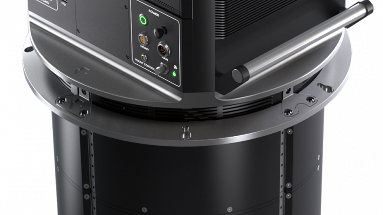
Phase One has unveiled the PAS 880, a fully integrated large-format nadir and oblique camera system for aerial mapping. The PAS 880 integrates a 280MP nadir camera with four oblique 150MP cameras into a single pod to simultaneously capture photogrammetric 2D and 3D digital imagery.
“The outstanding image quality and accuracy combined with unsurpassed data collection rate make the PAS 880 the most productive large-format aerial mapping solution on the market today, based on established Phase One technology,” said Dov Kalinski, Phase One vice president of geospatial business.
Operating at a 2 frames/second capture rate, the PAS 880 covers extremely wide flight lines with 20,000 pixels across in nadir and 14,000 pixels in each of the oblique angles. The system can be operated at a variety of airspeeds, altitudes, and lighting conditions for cost-effective blur-free image collection, with a maximum spatial resolution of 2.5 centimetres at 600 metres altitude. The combination of 90mm nadir and 150mm oblique camera lenses ensures balanced ground resolution.
City mapping
According to Phase One, the high-resolution 2D imagery collected by the PAS 880 will meet or exceed traditional photogrammetric nadir mapping requirements supported with oblique images, while the combination of nadir and oblique for 3D data will be very suitable for city mapping and related applications where a 360-degree perspective is required. These include Smart City management such as municipal planning and environmental monitoring as well as insurance, asset inventories, tax assessment, computer simulations, reality/digital twin capture, and mass modelling.
“We designed the PAS 880 with the same reliability and affordability our aerial mapping customers have come to expect from a Phase One solution, ensuring an ROI that is unmatched by other oblique and nadir systems,” said Kalinski.
The PAS 880 is a tightly coupled hardware and software system. Each system is delivered with a seamlessly integrated high-level GNSS/IMU, where customers can choose between two accuracy levels.
The PAS 880 comes equipped with the new generation of Phase One flight and sensor management software, developed for efficient, effective, and economical management of the entire oblique and nadir data capture workflow. The software includes iX Plan for mission planning; iX Flight Pro for flight management, data collection and image-status monitoring; and iX Process for fast and high-quality image processing. Phase One designed an open system to allow for additional processing with third-party photogrammetric applications.
To learn more on the PPA 880 nadir and oblique camera system, see here.

Value staying current with geomatics?
Stay on the map with our expertly curated newsletters.
We provide educational insights, industry updates, and inspiring stories to help you learn, grow, and reach your full potential in your field. Don't miss out - subscribe today and ensure you're always informed, educated, and inspired.
Choose your newsletter(s)


