Portable Lidar Mapping to Capture Historic Cave
A professor and undergraduate students from James Madison University have geospatially scanned the oldest show cave in the USA, Grand Caverns in Virginia, and digitally mapped the largest room in 3D for the very first time.
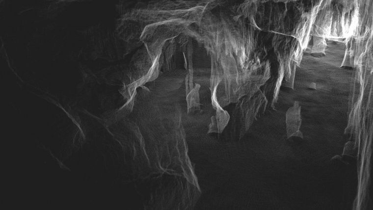
Open to the public since 1806, Grand Caverns has been a tourist attraction for more than two centuries. The show cave boasts geographic beauty, extensive nature trails in the surrounding area and forms part of Virginia’s rich history. 3D mapping the site marks the start of another chapter in the cavern’s future.
Using GeoSLAM’s handheld ZEB Horizon scanner, geology and environmental science assistant professor Angel A. Garcia Jr from James Madison University (JMU) in Harrisonburg, Virginia, has led a team of students in creating a digital map of the historic cave rooms. With a collection rate of 300,000 points per second, an accuracy of up to 6mm and the ability to scan data with a range capacity of 100m, the ZEB Horizon captured a detailed 3D point cloud of the entire system of caves in just over 12 minutes.
Mapping without GNSS signals
The ZEB Horizon’s ‘walk and scan’ method of geospatial data collection offers fully mobile technology. Powered by SLAM (Simultaneous Localization and Mapping) technology, the device does not require GNSS signals, which enabled Professor Garcia Jr and his team of students to carry out the scan below ground level. Once collected, the 3D point cloud was processed in GeoSLAM Hub, and measured using GeoSLAM Draw. The collected data is being used to measure speleothem formations, monitor human impact, create 3D printed models and provide an insight into the geo-heritage of the cave.
The ZEB Horizon’s easy-to-use walk-and-scan method of data collection meant the students could have valuable hands-on experience, applying their theoretical knowledge to practical real-world scenarios.
Throughout the summer, the university team continued to scan and monitor the cave, and Professor Garcia Jr. is working with caving experts to begin capturing new passages. These challenging areas have not been made accessible to the public due to uneven surfaces and narrow corridors, but the ZEB-Horizon’s mobile functionality enables the previously unseen parts of the cave to be mapped quickly and safely.

Solution for challenging environments
Speaking about the project, Angel A. Garcia Jr said: “A cave system often presents challenging environments for scanning, with narrow passageways, uneven surfaces, difficult terrain and areas presenting dangerous conditions. Unlike traditional tripod-based terrestrial laser scanners, GeoSLAM’s handheld device doesn’t require complicated assembly or professional survey experience to operate successfully."
“The versatility and easy-to-use functionality of the ZEB Horizon makes this the ideal device for this project. Scanning the Grand Caverns has presented a fantastic opportunity for the undergraduate students to dive straight into the project, gaining hands-on, practical experience in using Lidar handheld scanners, not to mention working with the data it outputs, without needing extensive technical training beforehand.”
The full scan of the Grand Caverns is shown in the video below.

Value staying current with geomatics?
Stay on the map with our expertly curated newsletters.
We provide educational insights, industry updates, and inspiring stories to help you learn, grow, and reach your full potential in your field. Don't miss out - subscribe today and ensure you're always informed, educated, and inspired.
Choose your newsletter(s)


